IMAGES TAKEN NEAR TO
Gooder Lane, BRIGHOUSE, HD6 1HT
Introduction
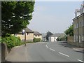
This page details the photographs taken nearby to Gooder Lane, HD6 1HT by members of the Geograph project.
The Geograph project started in 2005 with the aim of publishing, organising and preserving representative images for every square kilometre of Great Britain, Ireland and the Isle of Man.

There are currently over 7.5m images from over14,400 individuals and you can help contribute to the project by visiting https://www.geograph.org.uk
Image Map
Images are licensed for reuse under creativecommons.org/licenses/by-sa/2.0
Notes
- Clicking on the map will re-center to the selected point.
- The higher the marker number, the further away the image location is from the centre of the postcode.
Image Listing (426 Images Found)
Images are licensed for reuse under creativecommons.org/licenses/by-sa/2.0
Image
Details
Distance
1
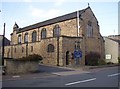
Church of St John the Divine, Rastrick
This CofE church was consecrated in 1915 to serve the lower part of Rastrick, which had been developed as a 19C suburb to Brighouse with many terrace houses.
Image: © Humphrey Bolton
Taken: 22 Sep 2005
0.02 miles
2
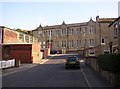
Former Victoria School
Victoria School was built in 1893 and made into a senior elementary school (ages 11-14) in 1921, and a secondary modern school c.1948. It was closed in 1969 and pupils transferred to a new school at Lightcliffe. It is now a Youth Centre.
Image: © Humphrey Bolton
Taken: 22 Sep 2005
0.02 miles
3
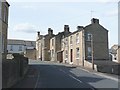
Healey Wood Road, Rastrick
Here starting a hairpin bend as it climbs steeply to the residential area that has replaced Healey Wood. The former Victoria School is on the left, and the white houses are the back of Tile Terrace. Victoria Place is the street on the right.
Image: © Humphrey Bolton
Taken: 15 Aug 2008
0.02 miles
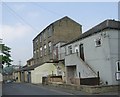
4
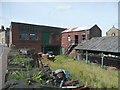
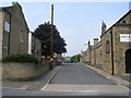
Factory, Healey Wood Road, Rastrick
There is still small-scale industry amongst the Victorian houses. These premises are captioned 'Timber Yard' on the OS map but look to be awaiting a new use.
Image: © Humphrey Bolton
Taken: 15 Aug 2008
0.02 miles
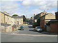
7
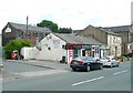
Shops, Gooder Lane, Rastrick
A row of four lock-up shops where four terrace houses might have been. The tall brick building (in a poor state of repair) has a sign for Martins Garage.
Image: © Humphrey Bolton
Taken: 4 Jul 2009
0.02 miles
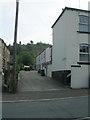
8
Laura Street - Gooder Lane
The white building on the right was the subject of an explosion and fire in the early hours of the 30th June 2009
Image: © Betty Longbottom
Taken: 29 Jun 2009
0.03 miles