IMAGES TAKEN NEAR TO
Huddersfield Road, BRIGHOUSE, HD6 1HA
Introduction
This page details the photographs taken nearby to Huddersfield Road, HD6 1HA by members of the Geograph project.
The Geograph project started in 2005 with the aim of publishing, organising and preserving representative images for every square kilometre of Great Britain, Ireland and the Isle of Man.

There are currently over 7.5m images from over14,400 individuals and you can help contribute to the project by visiting https://www.geograph.org.uk
Image Map
Images are licensed for reuse under creativecommons.org/licenses/by-sa/2.0
Notes
- Clicking on the map will re-center to the selected point.
- The higher the marker number, the further away the image location is from the centre of the postcode.
Image Listing (794 Images Found)
Images are licensed for reuse under creativecommons.org/licenses/by-sa/2.0
Image
Details
Distance
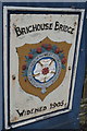
2
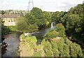
River Calder from Huddersfield Road, Brighouse
This is looking downstream from the bridge. The remains of the weir, now breached, can be seen.
Image: © Humphrey Bolton
Taken: 7 Aug 2006
0.02 miles
3
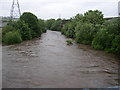
The River Calder in spate, Brighouse
Looking downstream from Brighouse Bridge (Huddersfield Road).
Image: © Humphrey Bolton
Taken: 25 Jun 2007
0.02 miles
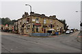
4
Property on the corner, Rastrick
The corner is between Birds Royd Lane and Huddersfield Road. The shop has been empty for a long time. It still has an old wooden shop front.
Image: © Humphrey Bolton
Taken: 12 Sep 2007
0.02 miles
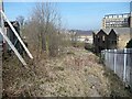
5
Derelict factory, Birds Royd Lane
This was Calder Bank Mills. I expect that it will be demolished in due course, unlike Mill Royd Mill over the river, the penthouse apartments of which can be seen in the distance.
Image: © Humphrey Bolton
Taken: 12 Sep 2007
0.02 miles
6
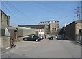
Princess Street, Rastrick
On the left some old buildings have been demolished to make a car park. Further down, Calder Bank Mills (silk) were on both sides of the street, whilst the Prince of Wales Mill (silk) was in the foreground on the right, replaced by a modern building.
Image: © Humphrey Bolton
Taken: 18 Mar 2009
0.02 miles
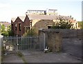
7
Site of Quaker burial ground, Birds Royd Lane, Rastrick
I keep peering over the fence to see if there are any gravestones, but without success. I expect they have gone by now, but as the site has not been developed maybe the graves are still there.
Image: © Humphrey Bolton
Taken: 18 Mar 2009
0.02 miles
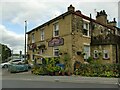
8
The Railway, Gooder Lane, Brighouse
This juicer stands on the corner of Gooder Lane and the A641 Huddersfield Road. There's a nice little, relaxing al fresco area out front, among the traffic lights.
Image: © Bobby Clegg
Taken: 26 Aug 2015
0.03 miles
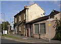
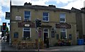
9
The Railway pub, Brighouse
Formerly the Commercial Image, and still bearing Tetley lamps (right hand side) renamed at some time since Brighouse station reopened nearby in 2000.
Image: © Stephen Craven
Taken: 4 Jul 2022
0.03 miles