IMAGES TAKEN NEAR TO
Owler Ings Road, BRIGHOUSE, HD6 1EJ
Introduction
This page details the photographs taken nearby to Owler Ings Road, HD6 1EJ by members of the Geograph project.
The Geograph project started in 2005 with the aim of publishing, organising and preserving representative images for every square kilometre of Great Britain, Ireland and the Isle of Man.

There are currently over 7.5m images from over14,400 individuals and you can help contribute to the project by visiting https://www.geograph.org.uk
Image Map
Images are licensed for reuse under creativecommons.org/licenses/by-sa/2.0
Notes
- Clicking on the map will re-center to the selected point.
- The higher the marker number, the further away the image location is from the centre of the postcode.
Image Listing (852 Images Found)
Images are licensed for reuse under creativecommons.org/licenses/by-sa/2.0
Image
Details
Distance
1
Owlerings Road car park
On the site of Spring Bank Works
Image: © Roger Templeman
Taken: 18 Jul 2018
0.02 miles
2
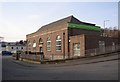
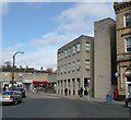
Job Centre Plus, Owler Ings Road, Brighouse
A typical neo-Georgian mid-20C government building, with large arched windows and a doorway to match. Over the door 'Employers and Juveniles' is carved in stone. The entrance for everyone is now round the corner in Spring Street.
Image: © Humphrey Bolton
Taken: 23 Mar 2006
0.02 miles
4
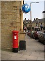
Edward VII pillar box, Thornton Square, Brighouse
Next to a bank. Replaced in 2008, see Image
Image: © Humphrey Bolton
Taken: 27 Apr 2007
0.02 miles
5
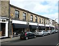
86 to 92 Commercial Street, Brighouse
This row of shops has been taken over by the furniture store on the left (shown in the next photograph).
Image: © Humphrey Bolton
Taken: 7 Mar 2008
0.02 miles
6
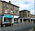
94 to 98 Commercial Street, Brighouse
Church Lane used to lead to the church (not surprisingly!) but is now only a short street leading to the bus station. The building on the left is shown on the 1850 OS map, and the one on the right not until a map of c. 1870.
Image: © Humphrey Bolton
Taken: 7 Mar 2008
0.02 miles
7
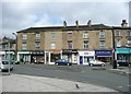
100 to 110 Commercial Street, Brighouse
The longest block of old buildings in the street, and shown on the 1850 OS map. A curious feature is that they all taper slightly from front to back. Although this is now part of Commercial Street, it was originally the bottom end of Halifax Road (assuming that the latter started at the top of Briggate, from which this photograph was taken).
Image: © Humphrey Bolton
Taken: 7 Mar 2008
0.02 miles
8
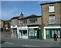
112 to 116 Commercial Street, Brighouse
The last three shops along Commercial Street. The pair with the pyramid roof look to be possibly of the 18C, with those mullioned windows, and would have faced onto Halifax Road before Commercial Street was constructed. On the left side Parsonage Lane went up to the Vicarage on the west side of St Martin's Church. Now it only goes up to the Methodist Sunday School and is then blocked off by the bypass road.
Image: © Humphrey Bolton
Taken: 11 Mar 2008
0.02 miles
9
Wellington House, Briggate, Brighouse
Part of the redevelopment of property between Briggate, Commercial Street and Market Street.
Image: © Humphrey Bolton
Taken: 11 Mar 2008
0.02 miles
10
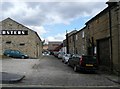
Heaton Street, off Church Lane, Brighouse
Still on the street map, but little more than a yard behind Webster's furniture shop (to the right). The building on the left was a row of back-to-backs on the 1907 map, the other side facing Gooder Street.
Image: © Humphrey Bolton
Taken: 31 Mar 2008
0.02 miles