IMAGES TAKEN NEAR TO
Martin Street, BRIGHOUSE, HD6 1DA
Introduction
This page details the photographs taken nearby to Martin Street, HD6 1DA by members of the Geograph project.
The Geograph project started in 2005 with the aim of publishing, organising and preserving representative images for every square kilometre of Great Britain, Ireland and the Isle of Man.

There are currently over 7.5m images from over14,400 individuals and you can help contribute to the project by visiting https://www.geograph.org.uk
Image Map
Images are licensed for reuse under creativecommons.org/licenses/by-sa/2.0
Notes
- Clicking on the map will re-center to the selected point.
- The higher the marker number, the further away the image location is from the centre of the postcode.
Image Listing (841 Images Found)
Images are licensed for reuse under creativecommons.org/licenses/by-sa/2.0
Image
Details
Distance
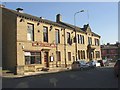
1
Dentist, Bradford Road, Brighouse
These look to have been built as rather superior terrace houses, the one on the right being double-fronted and quite large. Two of them are now occupied by a dental practice - note the large tooth hung up by the door!
Image: © Humphrey Bolton
Taken: 8 Sep 2006
0.02 miles
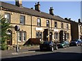
2
Restaurant and Liberal Club, Bradford Road, Brighouse
The Liberal Club was built in 1877. On the 1907 1:2500 map a gap was shown between the buildings, and close examination shows that the right-most bay of the Great Wall of China has been very skilfully added at some stage, with only slight discrepancies in the courses of stone and in the gutter.
Image: © Humphrey Bolton
Taken: 8 Sep 2006
0.02 miles
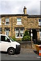
3
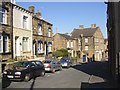
Martin Street, Brighouse
On the left, part of a row of terrace houses with fancy lintels. To the right a large building containing shops facing Bradford Road.
Image: © Humphrey Bolton
Taken: 8 Sep 2006
0.02 miles
4
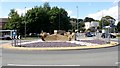
The 'Brighouse and Rastrick' roundabout, Brighouse
I previously called this the Tesco roundabout, but now it has a new centrepiece cut out of solid rock and inscribed 'The world famous Brighouse and Rastrick', which assumes that everyone knows that this is a brass band!
Image: © Humphrey Bolton
Taken: 16 Jul 2007
0.02 miles

6
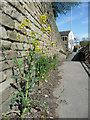
Wild cabbage plant, L?denscheid Way, Brighouse
Not a true wild cabbage, but probably grown from wind-blown seed from cabbages grown in planters by the 'Incredible Edible' volunteers. It is a very tall plant to have grown in the thin layer of poor soil that has accumulated along the edge of the footway.
Image: © Humphrey Bolton
Taken: 7 Apr 2020
0.02 miles
7
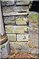
Benchmark on wall outside #16 High Street
Ordnance Survey cut mark benchmark described on the Bench Mark Database at https://www.bench-marks.org.uk/bm49215
Image: © Roger Templeman
Taken: 31 Jul 2018
0.02 miles
8
#16 High Street
There is an OS benchmark Image on the corner of the wall right of the lamppost
Image: © Roger Templeman
Taken: 31 Jul 2018
0.02 miles
9
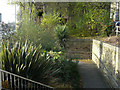
Exotic planting at the subway entrance, Bradford Road, Brighouse
Image: © Humphrey Bolton
Taken: 20 Nov 2019
0.02 miles
10
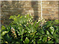
Fatshedera flowers, Bradford Road subway, Brighouse
The Fatshedera shrub is an inter-generic hybrid between fatsia (flower) and ivy (pollen). The flowers look like ivy flowers. The vertical white line behind is a joint in the retaining wall, presumably to absorb expansion during hot weather. They are a feature of the retaining walls all the way up Ludenscheid Link.
Image: © Humphrey Bolton
Taken: 20 Nov 2019
0.02 miles