IMAGES TAKEN NEAR TO
Larkfield Court, BRIGHOUSE, HD6 1AW
Introduction
This page details the photographs taken nearby to Larkfield Court, HD6 1AW by members of the Geograph project.
The Geograph project started in 2005 with the aim of publishing, organising and preserving representative images for every square kilometre of Great Britain, Ireland and the Isle of Man.

There are currently over 7.5m images from over14,400 individuals and you can help contribute to the project by visiting https://www.geograph.org.uk
Image Map
Images are licensed for reuse under creativecommons.org/licenses/by-sa/2.0
Notes
- Clicking on the map will re-center to the selected point.
- The higher the marker number, the further away the image location is from the centre of the postcode.
Image Listing (542 Images Found)
Images are licensed for reuse under creativecommons.org/licenses/by-sa/2.0
Image
Details
Distance
1
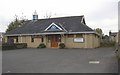
Churchfields Hall, Churchfields Road, Brighouse
This is a hall or chapel of the Christian Brethren. Quoting from a Wikipedia article: “The Open Brethren, sometimes called Christian Brethren or "Plymouth Brethren", are a group of Protestant Evangelical Christian churches that arose in the late 1820s as part of the Assembly Movement. They originated in England and Ireland and now have many assemblies world wide”.
Image: © Humphrey Bolton
Taken: 26 Oct 2007
0.01 miles
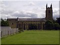
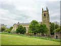
3
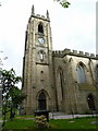
St Martin's Parish Church, Brighouse, Tower
Image: © Alexander P Kapp
Taken: 19 May 2010
0.04 miles
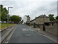
4
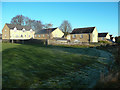
Houses in Larkfield Court, Brighouse
These are on the site of St Martin's C of E Secondary School, as shown on the 1960s to 70s 1:1250 map (Secondary Modern on the 1959 edition). Three buildings are shown, and they were an annexe to the school on Church Lane. The remainder of the housing estate is in what was Larkfield Works and before that. in 1959, a large house called Lark Field. In the grassed area in the foreground there was a shaft for mining sandstone, one of many in this area.
Image: © Humphrey Bolton
Taken: 29 Nov 2019
0.04 miles
7
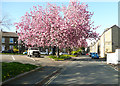
Cherry blossom, Churchfields Road, Brighouse
Image: © Humphrey Bolton
Taken: 13 Apr 2020
0.05 miles
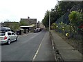
8
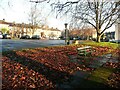
Car park between Church Lane and Churchfields Road
This is on the site of demolished back-to-back houses on Barton Street.
Image: © Humphrey Bolton
Taken: 26 Dec 2022
0.05 miles
9
St Martin's Parish Church, Brighouse
Image: © Alexander P Kapp
Taken: 19 May 2010
0.05 miles
10
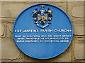
St Martin's Parish Church, Brighouse, Blue plaque
Image: © Alexander P Kapp
Taken: 19 May 2010
0.05 miles