IMAGES TAKEN NEAR TO
Wood Bottom Road, HUDDERSFIELD, HD4 7DJ
Introduction
This page details the photographs taken nearby to Wood Bottom Road, HD4 7DJ by members of the Geograph project.
The Geograph project started in 2005 with the aim of publishing, organising and preserving representative images for every square kilometre of Great Britain, Ireland and the Isle of Man.

There are currently over 7.5m images from over14,400 individuals and you can help contribute to the project by visiting https://www.geograph.org.uk
Image Map
Images are licensed for reuse under creativecommons.org/licenses/by-sa/2.0
Notes
- Clicking on the map will re-center to the selected point.
- The higher the marker number, the further away the image location is from the centre of the postcode.
Image Listing (14 Images Found)
Images are licensed for reuse under creativecommons.org/licenses/by-sa/2.0
Image
Details
Distance
1
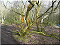
Unhappy tree, Honley Old Wood
The tree is twisted and has patches of orange lichen or fungus. It is possibly already dead
Image: © Humphrey Bolton
Taken: 7 Mar 2018
0.12 miles
2
Meltham Way, Honley Old Wood
The edge of a carboniferous sandstone bench forms a northwest-facing scarp slope 1.5km west of Honley. Here old woodland has been undisturbed for hundreds of years. The two footpaths in the photo are in fact a hairpin bend on the Meltham Way.
Image: © Richard Kay
Taken: 18 Jan 2011
0.13 miles
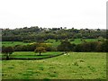
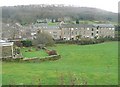
5
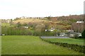
View towards Netherton from Wood Bottom Road, Honley
The line of trees marks the course of Hall Dike, and the steep hillside is Netherton Bank.
Image: © Humphrey Bolton
Taken: 3 Dec 2009
0.15 miles
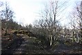
6
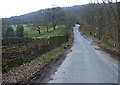
Honley Wood Bottom
This minor road climbs the Mag Brook valley to skirt Honley Wood. Here we have just crossed Hall Dike on Crosland Factory Lane.
Image: © michael ely
Taken: 3 Apr 2008
0.18 miles
7
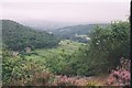
Netherton Edge - view south west towards Meltham
Image: © Dave Bevis
Taken: 1 Aug 2002
0.21 miles
8
What Next?
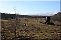
Here we see an infilled quarry in the middle of Honley Old Wood, or what is now known as the 'White Rose Forest', Honley. Nearby signs indicate that the quarry was worked by Johnson Wellfield Ltd., who operated several sandstone quarries in the area, extracting stone for building. The ground surface is now littered with methane monitoring points. What will be the long term future of this land which was formerly woodland?
Image: © Richard Kay
Taken: 18 Jan 2011
0.23 miles
9
Cocking Steps Mill, Honley
This building is unusual amongst old mills in being listed. It has been converted into dwellings without losing too much of the original appearance. Stone-faced houses have been built on the adjacent land.
Image: © Humphrey Bolton
Taken: 3 Dec 2009
0.23 miles
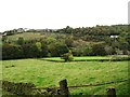
10
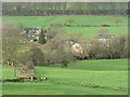
Lower Hall, South Crosland
This is a small group of buildings, seen here from Wood Bottom Road, that included a small woollen mill in 1850. The OS map now shows a moat, so it would seem that there was a manor house here long ago.
Image: © Humphrey Bolton
Taken: 3 Dec 2009
0.23 miles