IMAGES TAKEN NEAR TO
The Village, HUDDERSFIELD, HD4 6XX
Introduction
This page details the photographs taken nearby to The Village, HD4 6XX by members of the Geograph project.
The Geograph project started in 2005 with the aim of publishing, organising and preserving representative images for every square kilometre of Great Britain, Ireland and the Isle of Man.

There are currently over 7.5m images from over14,400 individuals and you can help contribute to the project by visiting https://www.geograph.org.uk
Image Map
Images are licensed for reuse under creativecommons.org/licenses/by-sa/2.0
Notes
- Clicking on the map will re-center to the selected point.
- The higher the marker number, the further away the image location is from the centre of the postcode.
Image Listing (49 Images Found)
Images are licensed for reuse under creativecommons.org/licenses/by-sa/2.0
Image
Details
Distance
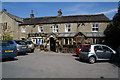
1
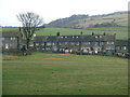
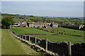
View northwest from the bench on Haw Cliff Lane
Houses in Thurstonland.
Image: © Christine Johnstone
Taken: 23 Feb 2012
0.03 miles
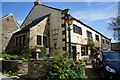
3
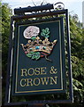
The Rose & Crown, Thurstonland
http://www.geograph.org.uk/photo/4468791
Image: © Ian S
Taken: 8 May 2015
0.04 miles
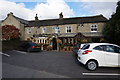
6
The Rose & Crown, Thurstonland
http://www.geograph.org.uk/photo/4468795
Image: © Ian S
Taken: 8 May 2015
0.05 miles
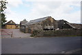
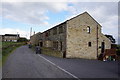
8
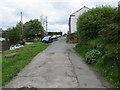
Lane joining The Village in Thurstonland
Looking north-eastward.
Image: © Peter Wood
Taken: 19 May 2019
0.06 miles