IMAGES TAKEN NEAR TO
Halstead Lane, HUDDERSFIELD, HD4 6XT
Introduction
This page details the photographs taken nearby to Halstead Lane, HD4 6XT by members of the Geograph project.
The Geograph project started in 2005 with the aim of publishing, organising and preserving representative images for every square kilometre of Great Britain, Ireland and the Isle of Man.

There are currently over 7.5m images from over14,400 individuals and you can help contribute to the project by visiting https://www.geograph.org.uk
Image Map
Images are licensed for reuse under creativecommons.org/licenses/by-sa/2.0
Notes
- Clicking on the map will re-center to the selected point.
- The higher the marker number, the further away the image location is from the centre of the postcode.
Image Listing (16 Images Found)
Images are licensed for reuse under creativecommons.org/licenses/by-sa/2.0
Image
Details
Distance
5
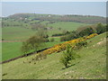
White Ley Bank, Fulstone
Looking across the route of the Holme Valley Circular Walk, with Hunger Hill and Upper Halstead near the skyline, and Halstead Wood to the right.
Image: © Barry Hurst
Taken: 4 May 2006
0.10 miles
6
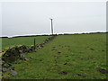
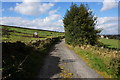
Telegraph pole on Haw Cliff hillside
In better condition than the broken-down field walls.
Image: © Christine Johnstone
Taken: 23 Feb 2012
0.14 miles
7
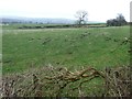
View east from the bench on Haw Cliff Lane
Molehills in the field alongside the lane.
Image: © Christine Johnstone
Taken: 23 Feb 2012
0.15 miles
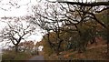
8
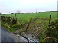
Informal field gate
On the south side of Haw Cliff Lane.
Image: © Christine Johnstone
Taken: 23 Feb 2012
0.15 miles
9
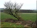
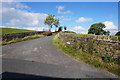
View north from the bench on Haw Cliff Lane
Which way does the wind blow?
Image: © Christine Johnstone
Taken: 23 Feb 2012
0.17 miles