IMAGES TAKEN NEAR TO
Thurstonland, HUDDERSFIELD, HD4 6XG
Introduction
This page details the photographs taken nearby to HD4 6XG by members of the Geograph project.
The Geograph project started in 2005 with the aim of publishing, organising and preserving representative images for every square kilometre of Great Britain, Ireland and the Isle of Man.

There are currently over 7.5m images from over14,400 individuals and you can help contribute to the project by visiting https://www.geograph.org.uk
Image Map
Images are licensed for reuse under creativecommons.org/licenses/by-sa/2.0
Notes
- Clicking on the map will re-center to the selected point.
- The higher the marker number, the further away the image location is from the centre of the postcode.
Image Listing (8 Images Found)
Images are licensed for reuse under creativecommons.org/licenses/by-sa/2.0
Image
Details
Distance
2
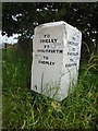
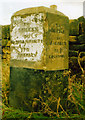
Old guidestone
From the style of hands this guidestone probably dates from about 1860/70. It is at the junction of Stocks Moor Road and Ing Head Lane and gives a choice of two routes to Shepley. Shelly is now spelt Shelley. It was painted about 2019. Grade II listed 1184002.
Image: © Chris Minto
Taken: 18 Jun 2023
0.06 miles
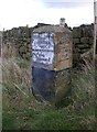
3
Old Guide Stone by Stocks Moor Road, Kirkburton parish
Stone post by the UC road, in parish of Kirkburton (Kirklees District), West of Stocksmoor, junction of Stocks Moor Road with Ing Head Lane.
Inscription reads:-
: {<-hand} TO / SHELLY / {hand->} TO / HOLMFIRTH / {<-hand} TO / SHEPLEY : : {hand->} TO / SHEPLEY / {<-hand} TO / FARNLEY / {hand->} TO / FULSTONE :
Grade II listed.
List Entry Number: 1184002 https://historicengland.org.uk/listing/the-list/list-entry/1184002
Surveyed
Milestone Society National ID: YW_XKIRd
Image: © Milestone Society
Taken: Unknown
0.07 miles
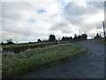
4
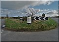
Road junction on Stocks Moor
With a freshly painted guide post. It didn't look so nice in past years. See https://www.geograph.org.uk/photo/6050403
Image: © Neil Theasby
Taken: 4 Feb 2020
0.07 miles
5
Guide stone at SE174107, Thurstonland, Yorkshire
There are other similar guide stones in this area. This points to Shelley and Shepley to the left, Holmfirth back up Butts Lane (this will be via Thurstonland village) and Fulstone to the right. It is not marked on the 1850 map, so could be late 19C.
Image: © Humphrey Bolton
Taken: 9 Feb 2006
0.11 miles
6
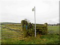
Footpath and stile on Ing Head Lane near Thurstonland
Image: © Steve Fareham
Taken: 24 Jan 2009
0.11 miles