IMAGES TAKEN NEAR TO
Low Common, HUDDERSFIELD, HD4 6ST
Introduction
This page details the photographs taken nearby to Low Common, HD4 6ST by members of the Geograph project.
The Geograph project started in 2005 with the aim of publishing, organising and preserving representative images for every square kilometre of Great Britain, Ireland and the Isle of Man.

There are currently over 7.5m images from over14,400 individuals and you can help contribute to the project by visiting https://www.geograph.org.uk
Image Map (Loading...)


Getting Data...Please wait
Leaflet Map data © OpenStreetMap
Images are licensed for reuse under creativecommons.org/licenses/by-sa/2.0
Notes
- Clicking on the map will re-center to the selected point.
- The higher the marker number, the further away the image location is from the centre of the postcode.
Image Listing (5 Images Found)
Images are licensed for reuse under creativecommons.org/licenses/by-sa/2.0
Image
Details
Distance
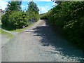
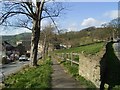
2
Sharp Lane Almondbury
Sharp Lane Almondbury at its junction with Lumb Lane looking NE.
Image: © Sue Trescott
Taken: 23 Dec 2005
0.14 miles
3
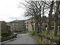
Northfield Mills, Almondbury Common
'Fancy woollen' manufacture, according to Old Maps. Castle Hill in the background
Image: © John Slater
Taken: 9 Apr 2014
0.18 miles
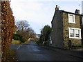
4
Lumb Lane Almondbury
Lumb Lane Almondbury looking WSW to Victoria Tower Castle Hill.
Image: © Sue Trescott
Taken: 23 Dec 2005
0.20 miles
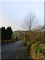
5
Almondbury Common.
Just a small piece left of the original Common Land.
Image: © Stanley Walker
Taken: 14 Mar 2007
0.20 miles