IMAGES TAKEN NEAR TO
Manchester Road, HUDDERSFIELD, HD4 5SF
Introduction
This page details the photographs taken nearby to Manchester Road, HD4 5SF by members of the Geograph project.
The Geograph project started in 2005 with the aim of publishing, organising and preserving representative images for every square kilometre of Great Britain, Ireland and the Isle of Man.

There are currently over 7.5m images from over14,400 individuals and you can help contribute to the project by visiting https://www.geograph.org.uk
Image Map
Images are licensed for reuse under creativecommons.org/licenses/by-sa/2.0
Notes
- Clicking on the map will re-center to the selected point.
- The higher the marker number, the further away the image location is from the centre of the postcode.
Image Listing (152 Images Found)
Images are licensed for reuse under creativecommons.org/licenses/by-sa/2.0
Image
Details
Distance
1
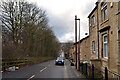
Former Fountain pub, Manchester Road A62, Milnsbridge, Linthwaite
I have been informed that this was the Fountain pub until it was closed in 1937. The house on the left is the Bar House (former turnpike toll house).
Image: © Humphrey Bolton
Taken: 3 Apr 2008
0.01 miles
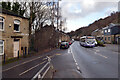
3
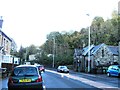
Manchester Road, Huddersfield
Looking east on the A62.
Image: © JThomas
Taken: 2 Nov 2018
0.01 miles
4
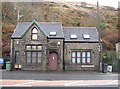
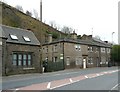
Former toll-house, Manchester Road, Milnsbridge, Linthwaite
This was a toll-house on the new turnpike road from Crosland Moor Bottom to Marsden, which opened in August 1832. The house was probably built around that date. Its position is such as to catch traffic coming down Pinfold Lane from the Lockwood direction. It has a blank stone tablet over the door. The house was derelict in 1991, but has thankfully been restored.
Image: © Humphrey Bolton
Taken: 6 Dec 2007
0.03 miles
5
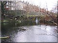
Lower millpond, off Manchester Road, Milnsbridge, Linthwaite
This is the older of the two millponds, and is on the 1850 6in map. It might have been used by the Spring Mill Brewery, although one would hope that they made beer from water taken directly from the spring! On the left is an elevated pipe, possibly a sewer draining the backs of the terrace houses.
Image: © Humphrey Bolton
Taken: 6 Dec 2007
0.03 miles
6
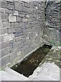
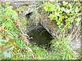
Well, Manchester Road A62, Milnsbridge, Linthwaite
Near to the junction with Park Road West. Probably the water supply for surrounding houses before mains water was provided.
Image: © Humphrey Bolton
Taken: 3 Apr 2008
0.03 miles
7
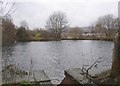
Upper millpond, off, Manchester Road, Milnsbridge, Linthwaite
Probably just used for fishing nowadays. I suppose the water, which enters from a pipe at top left, must be from springs as the hillside above is very steep with no sign of a valley. The channel in the foreground leads down to the lower pond.
Image: © Humphrey Bolton
Taken: 6 Dec 2007
0.03 miles
8
"Holy Well", Crosland Moor
See http://www.themodernantiquarian.com/site/5561/crosland_moor_holy_well.html.
This circular well, quite shallow, is as described at the end of the above article by 'Kozmik_Ken', in The Modern Antiquarian. However I suspect that the 'wishing well' that he knew as a boy might be elsewhere on the hillside.
Image: © Humphrey Bolton
Taken: 28 Jul 2009
0.03 miles
9
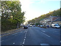
A bus passing the junction of Factory Lane and Manchester Road (A62), Milnsbridge
Image: © habiloid
Taken: 18 Feb 2021
0.03 miles