1
Spark Street Longwood
At the top of the steep cobbled hill of Spark Street, on Longwood Gate to the left, was the Baptist Sunday School where for 10 years I was a regular attender morning and afternoon. I have the books chosen by me as special prizes to be received on Prizegiving Day and a King James Bible presented for learning and reciting various psalms as evidence. I haven't suffered too much as a consequence. To the right was my first school now demolished.
Image: © Peter Turner
Taken: 29 Jan 2003
0.02 miles
2
Rock Street Longwood
A short street of millworkers' cottages and very much starved of sun but the backs of these cottages face west and hove small token enclosures, not really big enough to rejoice in the name of garden, where one may sit out in the afternoon sun. These are all through-houses and even have an under-dwelling/cellar with separate entrance door and window. The house for sale was my mother's home for over thirty years.
Image: © Peter Turner
Taken: 29 Jan 2003
0.05 miles
3
The Edge Accomodation
On Longwood Edge Road. http://www.geograph.org.uk/photo/5054967
Image: © Ian S
Taken: 27 Jul 2016
0.06 miles
4
Edge Terrace, Longwood
The house on the left is called 'The Cottage' on the 1850 6” map, and has two sets of 'weavers' windows', perhaps from the early 19C as the lights are quite large. There was a school on the grassy area to the left.
Image: © Humphrey Bolton
Taken: 20 May 2007
0.06 miles
5
The Edge Accommodation
On Longwood Edge Road. http://www.geograph.org.uk/photo/5054962
Image: © Ian S
Taken: 27 Jul 2016
0.06 miles
6
Building site, Longwood Gate, Longwood
Only a few weeks ago I took a photograph of Edge Terrace with a patch of grass on the left. Now this is hidden by steel site fencing, and an excavator is hard at work preparing the site of an old school for, presumably, town houses such as are going up in every vacant site in this area.
Image: © Humphrey Bolton
Taken: 28 Jun 2007
0.08 miles
7
Spark Street, Longwood
Not the ideal terrain for building houses, but they were needed close to the mills in the valley bottom. Spark Hall Terrace is on the left. The gently sloping hillside of Golcar Flat is in the distance.
Image: © Humphrey Bolton
Taken: 20 May 2007
0.08 miles
8
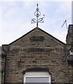
Finial, Spark Hall Terrace, Longwood
This is on a gable at the centre of the terrace, in Spark Street. The date is 1878 and the name of the terrace, deciphered after much peering, is across the gable just below eaves level. The asymmetry of the finial gives it a lively appearance.
Image: © Humphrey Bolton
Taken: 20 May 2007
0.08 miles
9
The Slip Inn
Image: © John Slater
Taken: 11 Oct 2014
0.08 miles
10
Dodlee from Longwood Edge
Image: © Ian S
Taken: 27 Jul 2016
0.09 miles


