IMAGES TAKEN NEAR TO
Benn Lane, HUDDERSFIELD, HD3 4RT
Introduction
This page details the photographs taken nearby to Benn Lane, HD3 4RT by members of the Geograph project.
The Geograph project started in 2005 with the aim of publishing, organising and preserving representative images for every square kilometre of Great Britain, Ireland and the Isle of Man.

There are currently over 7.5m images from over14,400 individuals and you can help contribute to the project by visiting https://www.geograph.org.uk
Image Map
Images are licensed for reuse under creativecommons.org/licenses/by-sa/2.0
Notes
- Clicking on the map will re-center to the selected point.
- The higher the marker number, the further away the image location is from the centre of the postcode.
Image Listing (98 Images Found)
Images are licensed for reuse under creativecommons.org/licenses/by-sa/2.0
Image
Details
Distance
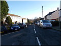
4
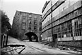
Sunnybank Mills, Longwood
This picture is slightly earlier than Dr Neil Clifton's Image and shows the mill building on the right before demolition was too far advanced. The mill building across the road was listed and retained but mysteriously collapsed one morning and was subsequently swept away. It was the demolition of Sunnybank Mills that spurred Jack Ramsay to write his excellent book "Made in Huddersfield".
I took several shots on this day and will be posting more.
Image: © Chris Allen
Taken: 30 May 1983
0.05 miles
5
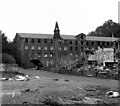
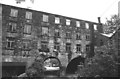
Derelict woollen mill, Longwood, near Huddersfield
This was Sunnybank Mill, owned by C. and J. Hirst. The road which is bridged over by the building is the bottom end of Grove Street: and the road coming down from the left at the extreme left end of the mill is Benn Lane. It appears that the mill was listed, but the arched part collapsed spontaneously so the whole structure was demolished. I am indebted to Chris Allen for this information.
Further information from Conrad Diamond informs me that the collapse was actually caused by a skip-wagon hitting the arch.
Image: © Dr Neil Clifton
Taken: 30 Oct 1985
0.05 miles
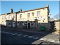
6
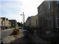
Prospect Road, Longwood
This road was made along the hillside in the 19C and lined with terrace houses for the workers in the nearby mills. Today only a few blocks remain, like the back-to-backs on the right, and terraces of three-storey town houses have been built instead. Longwood Church is in the distance.
Image: © Humphrey Bolton
Taken: 24 Sep 2005
0.06 miles
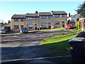
8
C & J Hirst, Sunnybank Mills
Photographed from the other side to Image This was the old part of Sunnybank Mills that spanned a split in the road. The owning company commenced in the 1870s and were in residence until 1979. There is now nothing left of this large complex of mills.
Image: © Chris Allen
Taken: 30 May 1983
0.08 miles
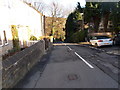
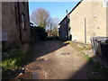
9
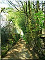
Path from Golcar to Longwood.
This pathway runs from near the lower end of Leymoor Road into Longwood.
Image: © Andrew Loughran
Taken: 6 Jul 2006
0.08 miles