IMAGES TAKEN NEAR TO
John Street, HUDDERSFIELD, HD3 4NP
Introduction
This page details the photographs taken nearby to John Street, HD3 4NP by members of the Geograph project.
The Geograph project started in 2005 with the aim of publishing, organising and preserving representative images for every square kilometre of Great Britain, Ireland and the Isle of Man.

There are currently over 7.5m images from over14,400 individuals and you can help contribute to the project by visiting https://www.geograph.org.uk
Image Map
Images are licensed for reuse under creativecommons.org/licenses/by-sa/2.0
Notes
- Clicking on the map will re-center to the selected point.
- The higher the marker number, the further away the image location is from the centre of the postcode.
Image Listing (301 Images Found)
Images are licensed for reuse under creativecommons.org/licenses/by-sa/2.0
Image
Details
Distance
4
![Cawlersley Lane Bridge [No. 33]](https://s1.geograph.org.uk/geophotos/01/88/61/1886141_b34b16af_120x120.jpg)
Cawlersley Lane Bridge [No. 33]
The parked cars and busy traffic are quite a contrast to the rambler on the towpath.
Image: © Christine Johnstone
Taken: 21 May 2010
0.03 miles
5
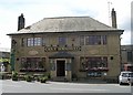
Four Horseshoes - Market Street, Milnsbridge
Image: © Betty Longbottom
Taken: 13 Aug 2008
0.03 miles
6
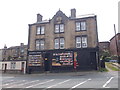
Milnsbridge Library - Morley Lane
Used as library 1940-1991.
Image: © Betty Longbottom
Taken: 10 May 2016
0.03 miles
7
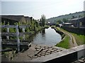
Huddersfield Narrow Canal, Milnsbridge
The pound between Library Lock [11E] and Spring Garden Lock [10E].
Image: © Christine Johnstone
Taken: 21 May 2010
0.03 miles
8
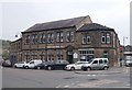
Christadelphian Hall - Morley Lane
Image: © Betty Longbottom
Taken: 10 May 2016
0.03 miles