IMAGES TAKEN NEAR TO
Crown Square, HUDDERSFIELD, HD3 4HR
Introduction
This page details the photographs taken nearby to Crown Square, HD3 4HR by members of the Geograph project.
The Geograph project started in 2005 with the aim of publishing, organising and preserving representative images for every square kilometre of Great Britain, Ireland and the Isle of Man.

There are currently over 7.5m images from over14,400 individuals and you can help contribute to the project by visiting https://www.geograph.org.uk
Image Map
Images are licensed for reuse under creativecommons.org/licenses/by-sa/2.0
Notes
- Clicking on the map will re-center to the selected point.
- The higher the marker number, the further away the image location is from the centre of the postcode.
Image Listing (63 Images Found)
Images are licensed for reuse under creativecommons.org/licenses/by-sa/2.0
Image
Details
Distance
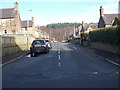
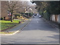
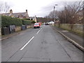
2
Longwood Road - viewed from Harp Road
Image: © Betty Longbottom
Taken: 11 Jan 2016
0.05 miles
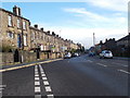
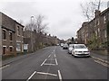
4
Quarmby Road - viewed from Royds Avenue
Image: © Betty Longbottom
Taken: 25 Jan 2016
0.07 miles
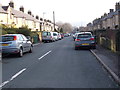
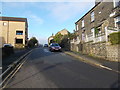
6
Longwood Road - viewed from Quarmby Road
Image: © Betty Longbottom
Taken: 25 Jan 2016
0.07 miles
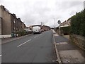
8
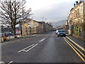
Longwood Road - viewed from Harp Road
Image: © Betty Longbottom
Taken: 11 Jan 2016
0.08 miles
10
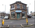
Huddersfield ... Society Ltd - Quarmby Road
Unfortunately part of the original title of the building is covered by the name of the current business.
Image: © Betty Longbottom
Taken: 25 Jan 2016
0.09 miles