IMAGES TAKEN NEAR TO
St. Annes Avenue, HUDDERSFIELD, HD3 3RU
Introduction
This page details the photographs taken nearby to St. Annes Avenue, HD3 3RU by members of the Geograph project.
The Geograph project started in 2005 with the aim of publishing, organising and preserving representative images for every square kilometre of Great Britain, Ireland and the Isle of Man.

There are currently over 7.5m images from over14,400 individuals and you can help contribute to the project by visiting https://www.geograph.org.uk
Image Map
Images are licensed for reuse under creativecommons.org/licenses/by-sa/2.0
Notes
- Clicking on the map will re-center to the selected point.
- The higher the marker number, the further away the image location is from the centre of the postcode.
Image Listing (105 Images Found)
Images are licensed for reuse under creativecommons.org/licenses/by-sa/2.0
Image
Details
Distance
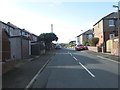
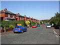
1
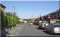
St Anne's Avenue, Ainley Top, Elland
The plan of this estate is a series of short cul-de-sacs off St George's Avenue, which runs parallel to St George's Avenue, the former A643. The houses are standard semis, at a low density compared with current developments! There is a play area at the end of the road, beyond which is the M62.
Image: © Humphrey Bolton
Taken: 9 Sep 2006
0.02 miles
4
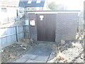
Electricity Substation No 2614 - Lindley Moor Road
Image: © Betty Longbottom
Taken: 27 Oct 2014
0.05 miles
5
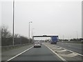
M62 slip road at Junction 24 to A629 at Ainley Top
Exit for Huddersfield and Halifax
Image: © Martin Dawes
Taken: 27 Mar 2017
0.06 miles
6
Halifax Road - viewed from Lindley Moor Road
Image: © Betty Longbottom
Taken: 27 Oct 2014
0.07 miles
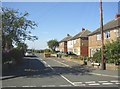
7
St George's Avenue, Ainley Top, Elland
The houses on the right front onto Lindley Moor Road, which used to be the A643 before the M62 was constructed. It looks as if there was a requirement that the garages should be at the back so that access to them was not from the main road. The road on the left is St Anne's Avenue, one of a series of short estate roads on the north side of St George's Avenue.
Image: © Humphrey Bolton
Taken: 9 Sep 2006
0.07 miles
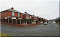
8
Lindley Moor Road, Ainley Top, Fixby
This was the main A643, and a turnpike road before that, but has now been bypassed due to the construction of a junction on the M62. The houses are typical mid-20C ribbon development, and are actually just over the boundary, in Elland.
Image: © Humphrey Bolton
Taken: 9 Sep 2006
0.07 miles
9
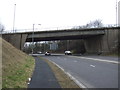
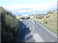
Bridge over the A629
Carrying Lindley Moor Road (A643).
Image: © JThomas
Taken: 14 Mar 2015
0.07 miles