IMAGES TAKEN NEAR TO
New Hey Road, HUDDERSFIELD, HD3 3FG
Introduction
This page details the photographs taken nearby to New Hey Road, HD3 3FG by members of the Geograph project.
The Geograph project started in 2005 with the aim of publishing, organising and preserving representative images for every square kilometre of Great Britain, Ireland and the Isle of Man.

There are currently over 7.5m images from over14,400 individuals and you can help contribute to the project by visiting https://www.geograph.org.uk
Image Map
Images are licensed for reuse under creativecommons.org/licenses/by-sa/2.0
Notes
- Clicking on the map will re-center to the selected point.
- The higher the marker number, the further away the image location is from the centre of the postcode.
Image Listing (51 Images Found)
Images are licensed for reuse under creativecommons.org/licenses/by-sa/2.0
Image
Details
Distance
1
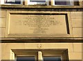
Memorial stone on former school building, New Hey Road, Outlane, Longwood
An unusual feature is that the lettering is done in dots.
Image: © Humphrey Bolton
Taken: 19 Apr 2007
0.01 miles
2
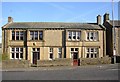
Former school, New Hey Road, Outlane, Longwood
Rebuilt in 1937 – see photograph of memorial stone.
Image: © Humphrey Bolton
Taken: 19 Apr 2007
0.01 miles
3
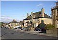
Waggon and Horses, New Hey Road, Outlane, Longwood
A good name for a pub at the junction of two former turnpike roads.
Image: © Humphrey Bolton
Taken: 19 Apr 2007
0.01 miles
5
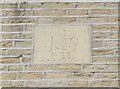
Datestone, New Hey Road, Outlane, Longwood
An elegantly inscribed stone. I have been informed that the letter at the top is Q for Quarmby, and J & S are for John and Sarah.
Image: © Humphrey Bolton
Taken: 26 Apr 2007
0.06 miles
6
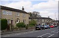
Houses, New Hey Road, Outlane, Longwood
The datestone is shown in image 415481.
Image: © Humphrey Bolton
Taken: 26 Apr 2007
0.06 miles
7
Houses, New Hey Road, Outlane, Longwood
Of various ages and heights. The ones in the centre were weavers' cottages, with their long rows of small mullioned windows to give a good light.
Image: © Humphrey Bolton
Taken: 27 Mar 2008
0.06 miles
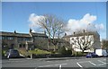
8
House on site of the Globe Inn, New Hey Road, Outlane, Old Lindley
The 1850 map shows the Globe Inn here, but it appears to have been redeveloped in the later 19C. However an inscribed stone over the archway refers to 'good stabling' (see 586796). Although this row of houses is now in the Kirklees Council area, the old boundary (between Longwood and the Old Lindley township division) ran along the road.
Image: © Humphrey Bolton
Taken: 15 Oct 2007
0.06 miles
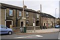
9
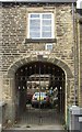
Good stabling, New Hey Road, Outlane, Old Lindley
The carved stone reads “D (?) W + S good stabling 1854”. In 1850 the Globe Inn was adjacent, at the end of Stainland Road, so perhaps this archway led to the stables behind the inn.
Image: © Humphrey Bolton
Taken: 15 Oct 2007
0.06 miles
10
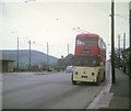
Huddersfield trolleybus at Outlane
Sunbeam S7 No 632 (PVH 932) waiting to depart on route 73 for Waterloo via town centre. It has East Lancs 72-seater bodywork dating from 1959. The trolleybus system closed down on 13th July, 1968, three months after this picture was taken.
Image: © David Hillas
Taken: 22 Apr 1968
0.06 miles