IMAGES TAKEN NEAR TO
Carew Road, NORTHWOOD, HA6 3NG
Introduction
This page details the photographs taken nearby to Carew Road, HA6 3NG by members of the Geograph project.
The Geograph project started in 2005 with the aim of publishing, organising and preserving representative images for every square kilometre of Great Britain, Ireland and the Isle of Man.

There are currently over 7.5m images from over14,400 individuals and you can help contribute to the project by visiting https://www.geograph.org.uk
Image Map
Images are licensed for reuse under creativecommons.org/licenses/by-sa/2.0
Notes
- Clicking on the map will re-center to the selected point.
- The higher the marker number, the further away the image location is from the centre of the postcode.
Image Listing (34 Images Found)
Images are licensed for reuse under creativecommons.org/licenses/by-sa/2.0
Image
Details
Distance
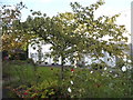
1
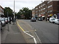
Town centre street scene Northwood
The railway station is at the top of the slope.
Image: © Jack Hill
Taken: 12 Jul 2005
0.11 miles
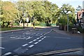
5
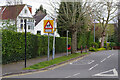
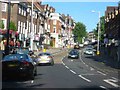
Carew Road, Northwood
Carew Road leads off Eastbury Road, running through to Watford Road. The name comes from F Murray Maxwell Hallowell Carew who bought land in Northwood following the arrival of the Metropolitan Railway in 1887 and then sold off building plots, naming some of the roads after himself. The style of street name sign on a single tall post is relatively unusual in the UK although it has been favoured by some local authorities over the years. The school sign refers to St Helen's School, out of shot to the right, an independent girls' school for pupils aged 3-18.
Image: © Stephen McKay
Taken: 5 Apr 2022
0.17 miles
7

Mermaids at the Ocean Gate
Making postbox toppers is a craze that can be found in different parts of the country but it has seriously caught on in the outer north-west London suburbs, including here on Eastbury Road, Northwood. The crochet designs are often anonymous but this one has a tag giving the work a title and naming the artist as Karinlighthouse 2021. A lot of effort has clearly gone into it and the effect is both colourful and really rather charming. Presumably Royal Mail has no objection - after all, the toppers are doing no harm and not impeding postal operations.
Image: © Stephen McKay
Taken: 5 Apr 2022
0.20 miles
8

Postbox topper tag - Eastbury Road, Northwood
The tag gives the name of the work and contact details for the artist who made the 'Mermaids at the Ocean Gate' postbox topper. See Image and Image for views of the artwork itself.
Image: © Stephen McKay
Taken: 5 Apr 2022
0.20 miles
9
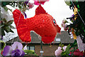
Mermaids at the Ocean Gate
This view shows part of the postbox topper on Eastbury Road. For a wider view and more information see Image
Image: © Stephen McKay
Taken: 5 Apr 2022
0.20 miles