IMAGES TAKEN NEAR TO
Langton Grove, NORTHWOOD, HA6 2PR
Introduction
This page details the photographs taken nearby to Langton Grove, HA6 2PR by members of the Geograph project.
The Geograph project started in 2005 with the aim of publishing, organising and preserving representative images for every square kilometre of Great Britain, Ireland and the Isle of Man.

There are currently over 7.5m images from over14,400 individuals and you can help contribute to the project by visiting https://www.geograph.org.uk
Image Map
Images are licensed for reuse under creativecommons.org/licenses/by-sa/2.0
Notes
- Clicking on the map will re-center to the selected point.
- The higher the marker number, the further away the image location is from the centre of the postcode.
Image Listing (79 Images Found)
Images are licensed for reuse under creativecommons.org/licenses/by-sa/2.0
Image
Details
Distance
3
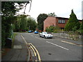
Hertfordshire/Greater London boundary, Northwood
The sign to the left of the image marks the boundary of the London Borough of Hillingdon. As well as being a borough boundary, this is also the county boundary between Hertfordshire and Greater London.
Image: © Malc McDonald
Taken: 8 Sep 2013
0.13 miles
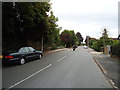
5
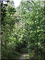
Footpath west of Kewferry Road (2)
Near the Image
Image: © Mike Quinn
Taken: 9 Oct 2019
0.15 miles
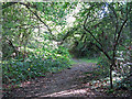
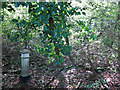
6
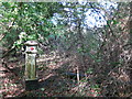
Dense woodland south of Batchworth Lane
Shows the location of Image
Image: © Mike Quinn
Taken: 9 Oct 2019
0.15 miles
7
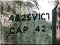
Coal tax boundary post no.54, west of Kewferry Road (detail) (2)
See Image and Image Here, two of the fixing holes for the correction plate can be seen, one by the "C" of "VICT" in the first line of the inscription, and the other below and to the left of the "C" of "CAP" in the second line.
Image: © Mike Quinn
Taken: 9 Oct 2019
0.15 miles
8
Coal tax boundary post no.54, west of Kewferry Road (detail)
See Image
Image: © Mike Quinn
Taken: 9 Oct 2019
0.15 miles
9
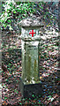
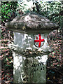
Coal tax boundary post no.54, west of Kewferry Road
The location of this post is shown in Image, Image, Image and Image
The post is Grade II listed https://historicengland.org.uk/listing/the-list/list-entry/1464598 .
There were originally nearly 280 coal tax posts located around London, of which about 210 are still extant; around 180 of these (85%) are 3 ft high white-painted square bollards with a pyramidal top, decorative raised bands, and the shield from the City of London’s arms, like this one. Photos of the coal tax posts on Geograph are at http://www.geograph.org.uk/search.php?i=86542993&page=1 .
The posts were erected under the Coal and Wine Duties (Continuation) Act of 1861 to mark the points at which duty had to be paid on coal being transported to London. The boundary was set at that of the Metropolitan Police District, and the resulting revenue was used by the Corporation of the City of London to fund public works. For further info see http://www.coaldutyposts.org.uk/cityposts.html .
Image: © Mike Quinn
Taken: 9 Oct 2019
0.15 miles
10
Dense woodland south of Batchworth Lane (2)
Shows the location of Image
Image: © Mike Quinn
Taken: 9 Oct 2019
0.16 miles