IMAGES TAKEN NEAR TO
Kewferry Drive, NORTHWOOD, HA6 2PA
Introduction
This page details the photographs taken nearby to Kewferry Drive, HA6 2PA by members of the Geograph project.
The Geograph project started in 2005 with the aim of publishing, organising and preserving representative images for every square kilometre of Great Britain, Ireland and the Isle of Man.

There are currently over 7.5m images from over14,400 individuals and you can help contribute to the project by visiting https://www.geograph.org.uk
Image Map
Images are licensed for reuse under creativecommons.org/licenses/by-sa/2.0
Notes
- Clicking on the map will re-center to the selected point.
- The higher the marker number, the further away the image location is from the centre of the postcode.
Image Listing (83 Images Found)
Images are licensed for reuse under creativecommons.org/licenses/by-sa/2.0
Image
Details
Distance
6
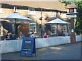
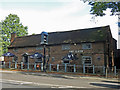
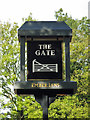
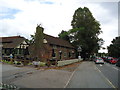
The Gate Pub at Northwood.
I think this pub was sited at the entrance to the town.
Image: © Jack Hill
Taken: 12 Jul 2005
0.15 miles
7
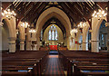
Holy Trinity, Northwood - Foundation stone
Image: © John Salmon
Taken: 11 Nov 2015
0.15 miles
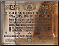
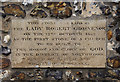
9
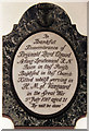
Holy Trinity, Northwood - Wall monument WWI
Image: © John Salmon
Taken: 11 Nov 2015
0.16 miles