IMAGES TAKEN NEAR TO
Rickmansworth Road, NORTHWOOD, HA6 2GY
Introduction
This page details the photographs taken nearby to Rickmansworth Road, HA6 2GY by members of the Geograph project.
The Geograph project started in 2005 with the aim of publishing, organising and preserving representative images for every square kilometre of Great Britain, Ireland and the Isle of Man.

There are currently over 7.5m images from over14,400 individuals and you can help contribute to the project by visiting https://www.geograph.org.uk
Image Map
Images are licensed for reuse under creativecommons.org/licenses/by-sa/2.0
Notes
- Clicking on the map will re-center to the selected point.
- The higher the marker number, the further away the image location is from the centre of the postcode.
Image Listing (57 Images Found)
Images are licensed for reuse under creativecommons.org/licenses/by-sa/2.0
Image
Details
Distance
2
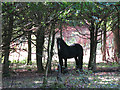
Horse in woodland between Rickmansworth Road and Farm Road
Image: © Mike Quinn
Taken: 9 Oct 2019
0.05 miles
3
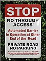
Friendly notice at the Kewferry Drive / Rickmansworth Road junction
See Image
Image: © Mike Quinn
Taken: 9 Oct 2019
0.06 miles
4
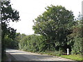
Rickmansworth Road south of Batchworth Lane (2)
Shows the location of Image
Image: © Mike Quinn
Taken: 9 Oct 2019
0.06 miles
5
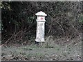
Coal post
There are a ring of these around London. See http://www.geograph.org.uk/photo/3368546 and http://www.geograph.org.uk/photo/3368543 for other examples. They mark positions where tax on coal and other commodities were taxed as they were brought into London. See http://en.wikipedia.org/wiki/Coal-tax_post for further information.
Image: © Bikeboy
Taken: 29 Mar 2013
0.07 miles
6
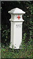
Coal tax boundary post no.55, Rickmansworth Road
The location of this post is shown in Image, Image and Image
The post is Grade II listed https://historicengland.org.uk/listing/the-list/list-entry/1100854 .
There were originally nearly 280 coal tax posts located around London, of which about 210 are still extant; around 180 of these (85%) are 3 ft high white-painted square bollards with a pyramidal top, decorative raised bands, and the shield from the City of London’s arms, like this one. Photos of the coal tax posts on Geograph are at http://www.geograph.org.uk/search.php?i=86542993&page=1 .
The posts were erected under the Coal and Wine Duties (Continuation) Act of 1861 to mark the points at which duty had to be paid on coal being transported to London. The boundary was set at that of the Metropolitan Police District, and the resulting revenue was used by the Corporation of the City of London to fund public works. For further info see http://www.coaldutyposts.org.uk/cityposts.html .
Image: © Mike Quinn
Taken: 9 Oct 2019
0.07 miles
7
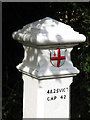
Coal tax boundary post no.55, Rickmansworth Road (detail)
See Image
Image: © Mike Quinn
Taken: 9 Oct 2019
0.07 miles
8
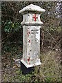
City Corporation Coal-Tax post, near the 'Prince of Wales', Batchworth Heath
Situated on the west side of the road, a short distance south of the 'Prince of Wales'. Being close to the road, this one is pretty grubby. It looks to me as if it must once have been painted red.
These posts date from the mid 19th century, when the City of London Corporation imposed a tax on coal (and other goods) entering the metropolitan area. They are said to mark points at which taxes were collected.
Much more history can be found on Martin Nail's website: http://www.coaldutyposts.org.uk/cityposts.html
Image: © Stefan Czapski
Taken: 31 Mar 2013
0.07 miles
10
Rickmansworth Road north of Mount Vernon Hospital
Image: © Mike Quinn
Taken: 9 Oct 2019
0.08 miles