IMAGES TAKEN NEAR TO
Adams Park Road, FARNHAM, GU9 9QG
Introduction
This page details the photographs taken nearby to Adams Park Road, GU9 9QG by members of the Geograph project.
The Geograph project started in 2005 with the aim of publishing, organising and preserving representative images for every square kilometre of Great Britain, Ireland and the Isle of Man.

There are currently over 7.5m images from over14,400 individuals and you can help contribute to the project by visiting https://www.geograph.org.uk
Image Map
Images are licensed for reuse under creativecommons.org/licenses/by-sa/2.0
Notes
- Clicking on the map will re-center to the selected point.
- The higher the marker number, the further away the image location is from the centre of the postcode.
Image Listing (41 Images Found)
Images are licensed for reuse under creativecommons.org/licenses/by-sa/2.0
Image
Details
Distance
1
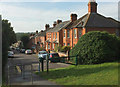
St James' Avenue, Farnham
Seen from the path shown in Image St James' Avenue is one of several parallel cul-de-sacs that run down to Hale Road.
Image: © Derek Harper
Taken: 17 Aug 2019
0.05 miles
2
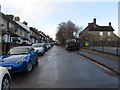
St James Avenue in Farnham
Looking north-westward.
Image: © Peter Wood
Taken: 27 Feb 2017
0.07 miles
3
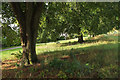
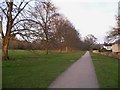
Farnham Park
Farnham footpath 98, the "narrow, gently curving asphalt footpath running along the southern boundary from the Bear Lane entrance gate in the south-west corner to the Bell Piece entrance in the south-east corner" https://historicengland.org.uk/listing/the-list/list-entry/1001499 passes the ends of neighbouring streets, and is "bordered with mature and semi-mature beech, lime, chestnut, and oak trees".
Image: © Derek Harper
Taken: 17 Aug 2019
0.08 miles
4
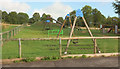
Play area, Farnham Park
Behind the camera in Image
Image: © Derek Harper
Taken: 17 Aug 2019
0.08 miles
5
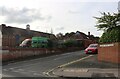
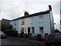
Adams Park Road, Farnham
Challengers Nursery is on the left.
Image: © David Howard
Taken: 11 Sep 2022
0.08 miles
6
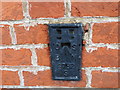
Ordnance Survey Flush Bracket S0782
This bracket can be found on the wall of The Challengers Play Centre in Farnham.
For more detail see : http://www.bench-marks.org.uk/bm12497
Image: © Peter Wood
Taken: 27 Feb 2017
0.08 miles
7
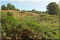
Hollow, Farnham Park
Probably one of the dells described at https://historicengland.org.uk/listing/the-list/list-entry/1001499 as marking "the site of old chalk pits cut into the chalk ridge".
Image: © Derek Harper
Taken: 17 Aug 2019
0.09 miles
8
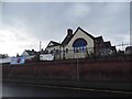
Play Centre on Hale Road, Farnham
Clearly a school, at least part of it is now a play centre.
Image: © David Howard
Taken: 11 Jul 2016
0.09 miles
9
A walk along the northern edge of Farnham looking east
Image: © Shazz
Taken: 3 Mar 2011
0.10 miles