IMAGES TAKEN NEAR TO
St. Georges Road, FARNHAM, GU9 9HR
Introduction
This page details the photographs taken nearby to St. Georges Road, GU9 9HR by members of the Geograph project.
The Geograph project started in 2005 with the aim of publishing, organising and preserving representative images for every square kilometre of Great Britain, Ireland and the Isle of Man.

There are currently over 7.5m images from over14,400 individuals and you can help contribute to the project by visiting https://www.geograph.org.uk
Image Map (Loading...)


Getting Data...Please wait
Leaflet Map data © OpenStreetMap
Images are licensed for reuse under creativecommons.org/licenses/by-sa/2.0
Notes
- Clicking on the map will re-center to the selected point.
- The higher the marker number, the further away the image location is from the centre of the postcode.
Image Listing (11 Images Found)
Images are licensed for reuse under creativecommons.org/licenses/by-sa/2.0
Image
Details
Distance
1
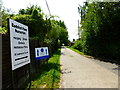
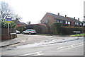
Spelling needs care
This is the drive at Badshot Farm Nurseries.
Image: © Shazz
Taken: 27 Jul 2014
0.15 miles
2
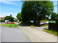
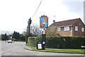
Animal shelter entrance in Badshot Lea
The main road ahead is Badshot Lea Road.
Image: © Shazz
Taken: 27 Jul 2014
0.20 miles
3
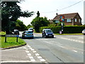
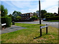
Badshot Lea Road at the junction with Beech Tree Drive
Image: © Shazz
Taken: 27 Jul 2014
0.21 miles
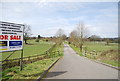
6
Junction of Crown Lane with Badshot Park and Beech Tree Drive
Image: © Shazz
Taken: 27 Jul 2014
0.22 miles
9
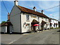
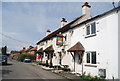
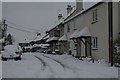
"The Crown" PH in Badshot Lea
For a snowy view see http://www.geograph.org.uk/photo/1632661.
Image: © Shazz
Taken: 27 Jul 2014
0.23 miles