IMAGES TAKEN NEAR TO
Wilkinson Way, FARNHAM, GU9 9FA
Introduction
This page details the photographs taken nearby to Wilkinson Way, GU9 9FA by members of the Geograph project.
The Geograph project started in 2005 with the aim of publishing, organising and preserving representative images for every square kilometre of Great Britain, Ireland and the Isle of Man.

There are currently over 7.5m images from over14,400 individuals and you can help contribute to the project by visiting https://www.geograph.org.uk
Image Map
Images are licensed for reuse under creativecommons.org/licenses/by-sa/2.0
Notes
- Clicking on the map will re-center to the selected point.
- The higher the marker number, the further away the image location is from the centre of the postcode.
Image Listing (16 Images Found)
Images are licensed for reuse under creativecommons.org/licenses/by-sa/2.0
Image
Details
Distance
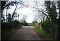
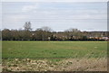
5
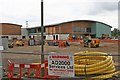
Weybourne
A large development beside the B3367. Not much information was to hand except a sign on part of the fencing proclaimed "New home for Farnham Rugby Football Club". Seems a little improbable!
Image: © Brendan and Ruth McCartney
Taken: 10 Jul 2011
0.15 miles
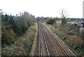
8
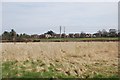
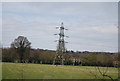
Rough Grazing by Green Lane
The Alton Line is behind the field.
Image: © N Chadwick
Taken: 14 Apr 2013
0.18 miles