IMAGES TAKEN NEAR TO
Laburnum Road, FARNHAM, GU9 9DU
Introduction
This page details the photographs taken nearby to Laburnum Road, GU9 9DU by members of the Geograph project.
The Geograph project started in 2005 with the aim of publishing, organising and preserving representative images for every square kilometre of Great Britain, Ireland and the Isle of Man.

There are currently over 7.5m images from over14,400 individuals and you can help contribute to the project by visiting https://www.geograph.org.uk
Image Map
Images are licensed for reuse under creativecommons.org/licenses/by-sa/2.0
Notes
- Clicking on the map will re-center to the selected point.
- The higher the marker number, the further away the image location is from the centre of the postcode.
Image Listing (15 Images Found)
Images are licensed for reuse under creativecommons.org/licenses/by-sa/2.0
Image
Details
Distance
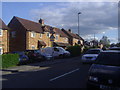
2
Brooklands Road, unadopted part
The road name is continuous, but a barrier ahead divides unadopted from adopted parts.
Image: © Robin Webster
Taken: 30 Jul 2015
0.11 miles
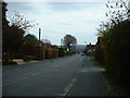
3
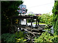
Barrier on Brooklands Road
It divides the adopted from the unadopted parts.
Image: © Robin Webster
Taken: 30 Jul 2015
0.13 miles
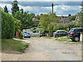
7
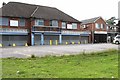
Heath End
Shops off North Avenue, adjacent to the A325.
Image: © Brendan and Ruth McCartney
Taken: 10 Jul 2011
0.21 miles
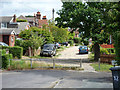
9
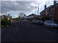
Weybourne Road at the junction of Lower Weybourne Road
Image: © David Howard
Taken: 12 May 2012
0.22 miles