IMAGES TAKEN NEAR TO
Farnborough Road, FARNHAM, GU9 9AE
Introduction
This page details the photographs taken nearby to Farnborough Road, GU9 9AE by members of the Geograph project.
The Geograph project started in 2005 with the aim of publishing, organising and preserving representative images for every square kilometre of Great Britain, Ireland and the Isle of Man.

There are currently over 7.5m images from over14,400 individuals and you can help contribute to the project by visiting https://www.geograph.org.uk
Image Map (Loading...)


Getting Data...Please wait
Leaflet Map data © OpenStreetMap
Images are licensed for reuse under creativecommons.org/licenses/by-sa/2.0
Notes
- Clicking on the map will re-center to the selected point.
- The higher the marker number, the further away the image location is from the centre of the postcode.
Image Listing (61 Images Found)
Images are licensed for reuse under creativecommons.org/licenses/by-sa/2.0
Image
Details
Distance
2
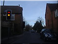
Junction at Hale
Ahead is the A325 Farnborough Road; left is the A3016 Upper Hale Road.
Image: © Derek Harper
Taken: 17 Sep 2018
0.11 miles
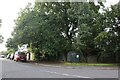
3
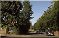
Hale Road at junction of Farnborough Road
Image: © David Howard
Taken: 13 Mar 2011
0.12 miles
4
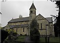
St John the Evangelist, Hale: churchyard (8)
Image: © Basher Eyre
Taken: 4 May 2012
0.14 miles
6
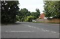
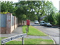
South Avenue at the junction of Farnborough Road
Image: © David Howard
Taken: 11 Sep 2022
0.14 miles
7
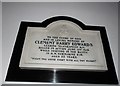
St John the Evangelist, Hale: memorial (C)
Image: © Basher Eyre
Taken: 4 May 2012
0.15 miles
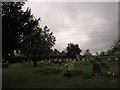
8
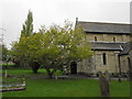
St John the Evangelist, Hale: churchyard (9)
Image: © Basher Eyre
Taken: 4 May 2012
0.15 miles
9

St John the Evangelist, Hale: notice board in the porch
Image: © Basher Eyre
Taken: 4 May 2012
0.15 miles