IMAGES TAKEN NEAR TO
Vicarage Close, FARNHAM, GU9 8EU
Introduction
This page details the photographs taken nearby to Vicarage Close, GU9 8EU by members of the Geograph project.
The Geograph project started in 2005 with the aim of publishing, organising and preserving representative images for every square kilometre of Great Britain, Ireland and the Isle of Man.

There are currently over 7.5m images from over14,400 individuals and you can help contribute to the project by visiting https://www.geograph.org.uk
Image Map (Loading...)


Getting Data...Please wait
Leaflet Map data © OpenStreetMap
Images are licensed for reuse under creativecommons.org/licenses/by-sa/2.0
Notes
- Clicking on the map will re-center to the selected point.
- The higher the marker number, the further away the image location is from the centre of the postcode.
Image Listing (6 Images Found)
Images are licensed for reuse under creativecommons.org/licenses/by-sa/2.0
Image
Details
Distance
1
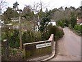
Signpost at the junction of Bourne Grove and Vicarage Hill
The signpost was erected in 2000 by the Farnham Ramblers and directs walkers on the Millennium Walk and The Switchback.
Image: © Shazz
Taken: 6 Mar 2011
0.09 miles
2
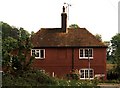
Willey Place Lodge
The windows at the right and the one upstairs in the middle were all bricked in to avoid the taxes. The right hand windows are merely black and white paint but they give the house a balance.
The House, a farmhouse in its own right, was built between 1650 and 1725.
Image: © Christopher Bruce
Taken: Unknown
0.16 miles
3
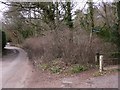
Bourne Grove looking west
The notice at the end announces the Spotted Cow PH.
Image: © Shazz
Taken: 6 Mar 2011
0.20 miles
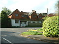
5
Lodge Hill Road, Farnham
In a very leafy neighbourhood southeast of the town. Showing one of the area's well proportioned houses.
Image: © Andrew Smith
Taken: 1 Jun 2008
0.22 miles
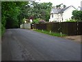
6

View by Frensham Road, Bourne
Looking towards The Fox pub.
Image: © David Howard
Taken: 11 Sep 2022
0.25 miles