IMAGES TAKEN NEAR TO
Longbridge, FARNHAM, GU9 7GG
Introduction
This page details the photographs taken nearby to Longbridge, GU9 7GG by members of the Geograph project.
The Geograph project started in 2005 with the aim of publishing, organising and preserving representative images for every square kilometre of Great Britain, Ireland and the Isle of Man.

There are currently over 7.5m images from over14,400 individuals and you can help contribute to the project by visiting https://www.geograph.org.uk
Image Map (Loading...)


Getting Data...Please wait
Leaflet Map data © OpenStreetMap
Images are licensed for reuse under creativecommons.org/licenses/by-sa/2.0
Notes
- Clicking on the map will re-center to the selected point.
- The higher the marker number, the further away the image location is from the centre of the postcode.
Image Listing (578 Images Found)
Images are licensed for reuse under creativecommons.org/licenses/by-sa/2.0
Image
Details
Distance


6
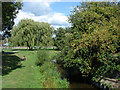
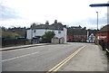
Gostrey Meadow, Farnham
A view across this recreation ground on the north bank of the River Wey.
Image: © Alan Hunt
Taken: 22 Aug 2014
0.04 miles
9

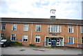
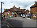
Farnham Maltings, Bridge Square, Farnham, Surrey
Image: © Oast House Archive
Taken: 13 Mar 2009
0.05 miles
10
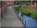
The Maltings, Farnham
The walkway along the River Wey by The Maltings.
Image: © Alan Hunt
Taken: 22 Aug 2014
0.05 miles