IMAGES TAKEN NEAR TO
Tor Road, FARNHAM, GU9 7BX
Introduction
This page details the photographs taken nearby to Tor Road, GU9 7BX by members of the Geograph project.
The Geograph project started in 2005 with the aim of publishing, organising and preserving representative images for every square kilometre of Great Britain, Ireland and the Isle of Man.

There are currently over 7.5m images from over14,400 individuals and you can help contribute to the project by visiting https://www.geograph.org.uk
Image Map
Images are licensed for reuse under creativecommons.org/licenses/by-sa/2.0
Notes
- Clicking on the map will re-center to the selected point.
- The higher the marker number, the further away the image location is from the centre of the postcode.
Image Listing (28 Images Found)
Images are licensed for reuse under creativecommons.org/licenses/by-sa/2.0
Image
Details
Distance
1
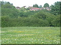
Byworth Road
Where town meets country. The westernmost fringe of Farnham visible across the fields.
Image: © Ben Gamble
Taken: 19 Jun 2005
0.03 miles
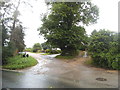
2
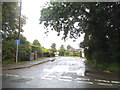
Three Stiles Road at the junction of Crondall Lane
Image: © David Howard
Taken: 11 Jul 2016
0.07 miles
3
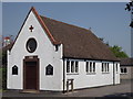
Byworth Church
St Francis at Byworth, a western suburb of Farnham.
Image: © Colin Smith
Taken: 23 May 2012
0.08 miles
4

Looking along Crondall Lane from the east end of Larkfield Road
Image: © Shazz
Taken: 3 Mar 2011
0.09 miles
5
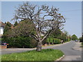
Byworth Road
Residential road in the Byworth area in western Farnham.
http://www.farnham.gov.uk/
Image: © Colin Smith
Taken: 23 May 2012
0.10 miles

7
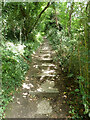
Steps on public footpath 1, Farnham
Climbing up from a stream crossing.
Image: © Robin Webster
Taken: 30 Jul 2015
0.12 miles
9

Twitten between Larkfield Close and Three Stiles Road
Image: © Shazz
Taken: 3 Mar 2011
0.13 miles
10
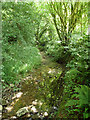
A tributary of the River Wey (North Branch)
Looking downstream.
Image: © Robin Webster
Taken: 30 Jul 2015
0.14 miles