IMAGES TAKEN NEAR TO
Waynflete Lane, FARNHAM, GU9 7BH
Introduction
This page details the photographs taken nearby to Waynflete Lane, GU9 7BH by members of the Geograph project.
The Geograph project started in 2005 with the aim of publishing, organising and preserving representative images for every square kilometre of Great Britain, Ireland and the Isle of Man.

There are currently over 7.5m images from over14,400 individuals and you can help contribute to the project by visiting https://www.geograph.org.uk
Image Map
Images are licensed for reuse under creativecommons.org/licenses/by-sa/2.0
Notes
- Clicking on the map will re-center to the selected point.
- The higher the marker number, the further away the image location is from the centre of the postcode.
Image Listing (23 Images Found)
Images are licensed for reuse under creativecommons.org/licenses/by-sa/2.0
Image
Details
Distance
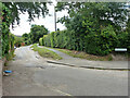
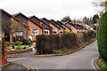
1
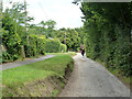
Waynflete Lane, Farnham
A private road but public footpath FP1.
Image: © Robin Webster
Taken: 30 Jul 2015
0.02 miles
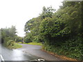
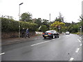
5
Waynflete Lane, Farnham
A private road but public footpath FP1. The county footpath map shows the right-of-way along the lane rather than the path on the right.
Image: © Robin Webster
Taken: 30 Jul 2015
0.07 miles
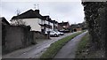
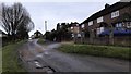
9
Bungalows on Parfitts Close, Farnham, Surrey
Image: © Oast House Archive
Taken: 13 Mar 2009
0.15 miles
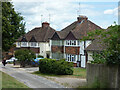
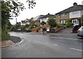
10
Byworth Road
Residential road in the Byworth area in western Farnham.
http://www.farnham.gov.uk/
Image: © Colin Smith
Taken: 23 May 2012
0.16 miles