IMAGES TAKEN NEAR TO
Alma Way, FARNHAM, GU9 0QN
Introduction
This page details the photographs taken nearby to Alma Way, GU9 0QN by members of the Geograph project.
The Geograph project started in 2005 with the aim of publishing, organising and preserving representative images for every square kilometre of Great Britain, Ireland and the Isle of Man.

There are currently over 7.5m images from over14,400 individuals and you can help contribute to the project by visiting https://www.geograph.org.uk
Image Map (Loading...)


Getting Data...Please wait
Leaflet Map data © OpenStreetMap
Images are licensed for reuse under creativecommons.org/licenses/by-sa/2.0
Notes
- Clicking on the map will re-center to the selected point.
- The higher the marker number, the further away the image location is from the centre of the postcode.
Image Listing (30 Images Found)
Images are licensed for reuse under creativecommons.org/licenses/by-sa/2.0
Image
Details
Distance
6
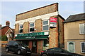
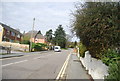
Optiplan Kitchens on Farnborough Road, Heath End
With a nice ghost sign above it.
Image: © David Howard
Taken: 11 Sep 2022
0.11 miles
8
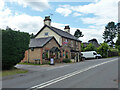
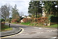
The Alma, Alma Lane, Hale
Several pubs are named after the Alma, which is a river that figured prominently in the Crimean War.
Image: © Robin Webster
Taken: 30 Jul 2015
0.12 miles
9
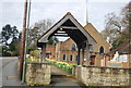
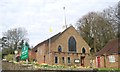
Lych gate, Catholic Church of The Holy Family
Image: © N Chadwick
Taken: 14 Apr 2013
0.13 miles