IMAGES TAKEN NEAR TO
Heath Lane, FARNHAM, GU9 0PU
Introduction
This page details the photographs taken nearby to Heath Lane, GU9 0PU by members of the Geograph project.
The Geograph project started in 2005 with the aim of publishing, organising and preserving representative images for every square kilometre of Great Britain, Ireland and the Isle of Man.

There are currently over 7.5m images from over14,400 individuals and you can help contribute to the project by visiting https://www.geograph.org.uk
Image Map (Loading...)


Getting Data...Please wait
Leaflet Map data © OpenStreetMap
Images are licensed for reuse under creativecommons.org/licenses/by-sa/2.0
Notes
- Clicking on the map will re-center to the selected point.
- The higher the marker number, the further away the image location is from the centre of the postcode.
Image Listing (29 Images Found)
Images are licensed for reuse under creativecommons.org/licenses/by-sa/2.0
Image
Details
Distance
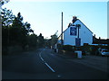
2
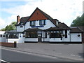
The Lobster Pot, Hale
A pub restaurant
Image: © Alex McGregor
Taken: 9 Jun 2011
0.08 miles
4
Hale Methodist Church
Grade II listed. http://www.britishlistedbuildings.co.uk/en-290961-hale-methodist-church-farnham-surrey
Image: © N Chadwick
Taken: 14 Apr 2013
0.13 miles
5
Hale Methodist Church
Grade II listed. http://www.britishlistedbuildings.co.uk/en-290961-hale-methodist-church-farnham-surrey
Image: © N Chadwick
Taken: 14 Apr 2013
0.13 miles
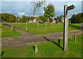
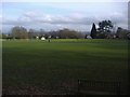
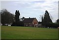
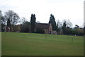
6
View across the recreation ground at Upper Hale
Image: © David Martin
Taken: 8 Jun 2014
0.15 miles
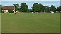
8
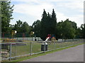
Playground
Playground on The Green, Farnham
Image: © Ben Gamble
Taken: 19 Jun 2005
0.16 miles