IMAGES TAKEN NEAR TO
Blackheath Road, FARNHAM, GU9 0DY
Introduction
This page details the photographs taken nearby to Blackheath Road, GU9 0DY by members of the Geograph project.
The Geograph project started in 2005 with the aim of publishing, organising and preserving representative images for every square kilometre of Great Britain, Ireland and the Isle of Man.

There are currently over 7.5m images from over14,400 individuals and you can help contribute to the project by visiting https://www.geograph.org.uk
Image Map (Loading...)


Getting Data...Please wait
Leaflet Map data © OpenStreetMap
Images are licensed for reuse under creativecommons.org/licenses/by-sa/2.0
Notes
- Clicking on the map will re-center to the selected point.
- The higher the marker number, the further away the image location is from the centre of the postcode.
Image Listing (19 Images Found)
Images are licensed for reuse under creativecommons.org/licenses/by-sa/2.0
Image
Details
Distance
1
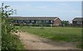
Sandy Hill
Houses at the edge of Farnham bordering onto heathland.
Image: © Ben Gamble
Taken: 19 Jun 2005
0.08 miles
3
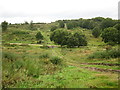
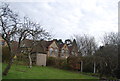
View towards Bricksbury Hill
The valley is the upper end of Long Bottom.
Image: © don cload
Taken: 10 Sep 2011
0.16 miles
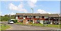
7
Hale Primary School
Grade II listed. http://www.britishlistedbuildings.co.uk/en-290782-premises-occupied-by-hale-county-junior-
Image: © N Chadwick
Taken: 14 Apr 2013
0.20 miles
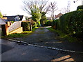
9
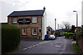
The Prince Alfred
Originally a smallish pub, there is now a single storey extension to the left out of sight, and a car park.
Image: © Robin Webster
Taken: 31 Mar 2007
0.22 miles
10
Hale Primary School
Grade II listed. http://www.britishlistedbuildings.co.uk/en-290782-premises-occupied-by-hale-county-junior-
Image: © N Chadwick
Taken: 14 Apr 2013
0.23 miles