IMAGES TAKEN NEAR TO
Old Park Lane, FARNHAM, GU9 0AL
Introduction
This page details the photographs taken nearby to Old Park Lane, GU9 0AL by members of the Geograph project.
The Geograph project started in 2005 with the aim of publishing, organising and preserving representative images for every square kilometre of Great Britain, Ireland and the Isle of Man.

There are currently over 7.5m images from over14,400 individuals and you can help contribute to the project by visiting https://www.geograph.org.uk
Image Map (Loading...)


Getting Data...Please wait
Leaflet Map data © OpenStreetMap
Images are licensed for reuse under creativecommons.org/licenses/by-sa/2.0
Notes
- Clicking on the map will re-center to the selected point.
- The higher the marker number, the further away the image location is from the centre of the postcode.
Image Listing (4 Images Found)
Images are licensed for reuse under creativecommons.org/licenses/by-sa/2.0
Image
Details
Distance
1
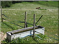
Water Trough
Vital for watering animals in downland environments.
Image: © Colin Smith
Taken: 23 May 2012
0.11 miles
2
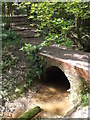
Footbridge in Claypit Wood
Carrying a footpath across a shallow stream in the bottom of a wooded valley.
Image: © Colin Smith
Taken: 23 May 2012
0.13 miles
3
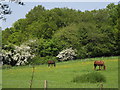
Grazing Near Farnham Castle
Chalk grassland below the woods west of Farnham Castle.
Image: © Colin Smith
Taken: 23 May 2012
0.20 miles
4
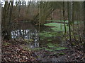
Claypit Wood
Flooded claypit workings. Archaeoligists speculate that it was the fine white clay from these woods that was used for the "Tudor Grene drinking potts" purchased by the Inns of Court in London.
Image: © Malcolm Delahaye
Taken: 27 Jan 2008
0.23 miles