IMAGES TAKEN NEAR TO
Franklin Court, GODALMING, GU8 5US
Introduction
This page details the photographs taken nearby to Franklin Court, GU8 5US by members of the Geograph project.
The Geograph project started in 2005 with the aim of publishing, organising and preserving representative images for every square kilometre of Great Britain, Ireland and the Isle of Man.

There are currently over 7.5m images from over14,400 individuals and you can help contribute to the project by visiting https://www.geograph.org.uk
Image Map (Loading...)


Getting Data...Please wait
Leaflet Map data © OpenStreetMap
Images are licensed for reuse under creativecommons.org/licenses/by-sa/2.0
Notes
- Clicking on the map will re-center to the selected point.
- The higher the marker number, the further away the image location is from the centre of the postcode.
Image Listing (76 Images Found)
Images are licensed for reuse under creativecommons.org/licenses/by-sa/2.0
Image
Details
Distance
1
All weather pitch within King Edward's School, Witley
Image: © Basher Eyre
Taken: 18 Oct 2009
0.02 miles
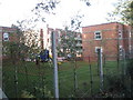
2
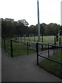
Looking from a footpath towards a hockey pitch at King Edward's School
Image: © Basher Eyre
Taken: 18 Oct 2009
0.02 miles
4
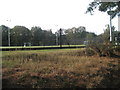
Mid section of the footpath from Brook Road to Culmer
Image: © Basher Eyre
Taken: 18 Oct 2009
0.02 miles
5

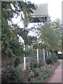
Approaching the footpath sign to King Edward's School in Brook Road
Image: © Basher Eyre
Taken: 18 Oct 2009
0.04 miles
6
Playpark within King Edward's School, Witley
Image: © Basher Eyre
Taken: 18 Oct 2009
0.04 miles
7
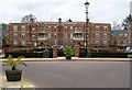
Wormley: Bridewell Park
Bridewell Park is a new housing apartment development by Charles Church http://www.charleschurch.com replacing the former Institute of Oceanographic Studies which used to be on this site, and indeed, according to the current Ordnance Survey 1:10,000 mapping, still is! The current 1:25,000 scale mapping though does show the new building illustrating that not all scales of mapping are kept up to date simultaneously. The picture also illustrates how sites close to railway stations (Witley in this case, about 10 minutes walk away) with direct links to London are popular with residential developers. The development however met with much opposition from local residents who feared that an instant increase in the number of homes in Wormley by about a third would have a detrimental effect on the local service infrastructure of utilities and roads. See http://www.cobhamnewsonline.co.uk/news/86/86051/planners___accused_of_fudging_homes_bid
Image: © Nigel Cox
Taken: 22 Feb 2008
0.05 miles
8
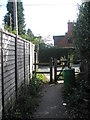
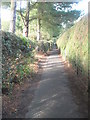
Footpath from King Edward's School approaching Brook Road
Image: © Basher Eyre
Taken: 18 Oct 2009
0.05 miles
9
Footpath from Brook Road to King Edward's School
Image: © Basher Eyre
Taken: 18 Oct 2009
0.06 miles
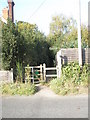
10
Looking from Brook Road into Bridewell Close
Image: © Basher Eyre
Taken: 18 Oct 2009
0.06 miles