IMAGES TAKEN NEAR TO
Petworth Road, GODALMING, GU8 5SB
Introduction
This page details the photographs taken nearby to Petworth Road, GU8 5SB by members of the Geograph project.
The Geograph project started in 2005 with the aim of publishing, organising and preserving representative images for every square kilometre of Great Britain, Ireland and the Isle of Man.

There are currently over 7.5m images from over14,400 individuals and you can help contribute to the project by visiting https://www.geograph.org.uk
Image Map (Loading...)


Getting Data...Please wait
Leaflet Map data © OpenStreetMap
Images are licensed for reuse under creativecommons.org/licenses/by-sa/2.0
Notes
- Clicking on the map will re-center to the selected point.
- The higher the marker number, the further away the image location is from the centre of the postcode.
Image Listing (61 Images Found)
Images are licensed for reuse under creativecommons.org/licenses/by-sa/2.0
Image
Details
Distance
1
Wormley: speed limit reminder
The sign has a detector which picks up the speeds of those exceeding the 40mph limit, and then displays the reminder '40' sign with flashing corner spots.
Image: © Chris Downer
Taken: 21 Jul 2009
0.01 miles
2
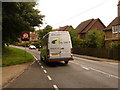
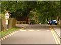
Car turning out of King Edward's School onto the A283 at Wormley
Image: © Basher Eyre
Taken: 18 Oct 2009
0.02 miles
3

Wormley: Coronation Cottages
A pair of semi-detached cottages, named Coronation Cottages and dated 1902 in the central slab.
Image: © Chris Downer
Taken: 21 Jul 2009
0.03 miles
5
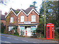
Wormley Post Office
Beside the iconic bright red telephone box, this post office probably makes a good trade from the King Edward's School which faces it.
Image: © Colin Smith
Taken: 7 Nov 2009
0.03 miles
6
Wormley: Ramp 3 yards
A road-sign up the driveway to King Edward's School, warning of the ramp which is just as visible as the sign! If anything, the '3 yards' is an overstatement.
Image: © Chris Downer
Taken: 21 Jul 2009
0.04 miles
7
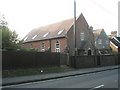
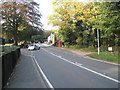
Converted chapel at Wormley on the A283
Image: © Basher Eyre
Taken: 18 Oct 2009
0.04 miles
8
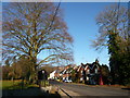
Wormley Post Office and adjacent cottages.
Wormley Post Office (closest building in the photograph) is located on the east side of Petworth Road (A283) and opposite the playing fields of King Edwards School. Photograph taken from the entrance to Gurdon's Lane on the west side of the A283.
Image: © Richard Durden
Taken: 3 Jan 2009
0.04 miles
9
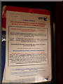
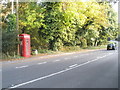
Wormley: phone box notice
This notice, inside the telephone box pictured in Image, explains that the box isn't being used sufficiently for BT to retain it – but a community gtoup can purchase the box for £1 to keep this quintessential English village icon in its present position.
Alternatively, a sponsorship of the telephone equipment is an option, whereby a community group subsidises the running of the service.
The consultation period begins next week.
Image: © Chris Downer
Taken: 21 Jul 2009
0.04 miles
10
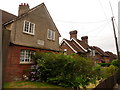
Wormley: Queen Alexandra and Preston Cottages
Neighbours of Image, here we see Queen Alexandra Cottages in the foreground, dated 1906 on the date-stone; and next door to those, a similar pair of semi-detached cottages named Preston Cottages and dated 1931 on a similar stone.
Image: © Chris Downer
Taken: 21 Jul 2009
0.05 miles