IMAGES TAKEN NEAR TO
Rodborough Hill Park, Portsmouth Road, GODALMING, GU8 5RY
Introduction
This page details the photographs taken nearby to Rodborough Hill Park, Portsmouth Road, GU8 5RY by members of the Geograph project.
The Geograph project started in 2005 with the aim of publishing, organising and preserving representative images for every square kilometre of Great Britain, Ireland and the Isle of Man.

There are currently over 7.5m images from over14,400 individuals and you can help contribute to the project by visiting https://www.geograph.org.uk
Image Map
Images are licensed for reuse under creativecommons.org/licenses/by-sa/2.0
Notes
- Clicking on the map will re-center to the selected point.
- The higher the marker number, the further away the image location is from the centre of the postcode.
Image Listing (4 Images Found)
Images are licensed for reuse under creativecommons.org/licenses/by-sa/2.0
Image
Details
Distance
2
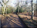
Bridleway by Mousehill Corner
Wide and smooth earthen track which is also used by wheeled traffic going to and from upmarket houses in the woods.
Image: © Colin Smith
Taken: 30 Jan 2011
0.22 miles
3
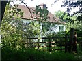
Mousehill Corner
Isolated cottage on the edge of the common.
Image: © Ben Gamble
Taken: 17 Jun 2006
0.23 miles
4
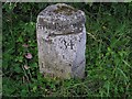
Old Milestone by the A3100, Portsmouth Road, Milford
Carved stone post by the A3100 (was A3), in parish of Godalming (Waverley District), Portsmouth Road, Milford, southbound slip-road, West of the entrance to Rodborough Common car park, on the verge, on South side of road. Guildford facets, erected by the Kingston & Sheetbridge, 1st District turnpike trust in the 19th century. Photo from 2020 https://www.facebook.com/groups/MilestoneSociety/permalink/9252867811417420/
Inscription reads:-
: LIPHOOK / 10 MILES : : HYDE PARK CORNER / 34 : : GODALMING / 2 MILES :
Milestone Society National ID: SY_LP34
Image: © Mike Galtray
Taken: 1 Jan 1900
0.24 miles