IMAGES TAKEN NEAR TO
Hartsgrove, GODALMING, GU8 4RG
Introduction
This page details the photographs taken nearby to Hartsgrove, GU8 4RG by members of the Geograph project.
The Geograph project started in 2005 with the aim of publishing, organising and preserving representative images for every square kilometre of Great Britain, Ireland and the Isle of Man.

There are currently over 7.5m images from over14,400 individuals and you can help contribute to the project by visiting https://www.geograph.org.uk
Image Map
Images are licensed for reuse under creativecommons.org/licenses/by-sa/2.0
Notes
- Clicking on the map will re-center to the selected point.
- The higher the marker number, the further away the image location is from the centre of the postcode.
Image Listing (4 Images Found)
Images are licensed for reuse under creativecommons.org/licenses/by-sa/2.0
Image
Details
Distance
1
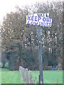
Kneecappings or Armed Dwarves?
Combe Common has more than one of these curious signposts. I didn't go too close to find out!
Image: © Colin Smith
Taken: 9 Dec 2006
0.04 miles
4
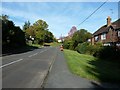
2020 vision: Day 63
Postbox in Woodside Road
Temperature 7C
BBC Radio 4 News Bulletin 16:00 Health officials say I in 5 may need to take time off if the Coronavirus becomes a pandemic
Image: © Basher Eyre
Taken: 3 Mar 2020
0.22 miles