IMAGES TAKEN NEAR TO
Shoppe Hill, GODALMING, GU8 4LW
Introduction
This page details the photographs taken nearby to Shoppe Hill, GU8 4LW by members of the Geograph project.
The Geograph project started in 2005 with the aim of publishing, organising and preserving representative images for every square kilometre of Great Britain, Ireland and the Isle of Man.

There are currently over 7.5m images from over14,400 individuals and you can help contribute to the project by visiting https://www.geograph.org.uk
Image Map (Loading...)


Getting Data...Please wait
Leaflet Map data © OpenStreetMap
Images are licensed for reuse under creativecommons.org/licenses/by-sa/2.0
Notes
- Clicking on the map will re-center to the selected point.
- The higher the marker number, the further away the image location is from the centre of the postcode.
Image Listing (48 Images Found)
Images are licensed for reuse under creativecommons.org/licenses/by-sa/2.0
Image
Details
Distance
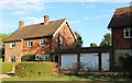
6
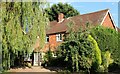
Dunsfold Cottages
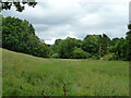
Cottages typical of this part of the country right on the very southern edge of this square (the buildings are in the square, even if the road isn't).
Image: © Ben Gamble
Taken: 10 Jul 2005
0.12 miles
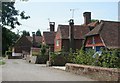
7
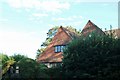
Gratton Corner Cottage
Grade II listed. http://www.britishlistedbuildings.co.uk/en-291764-gratton-corner-cottage-dunsfold-surrey
Image: © N Chadwick
Taken: 1 Jul 2012
0.14 miles
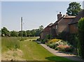
10
Church Road leading to Dunsfold church
Church Road arcs round and rejoins Hookhouse Lane further south.
Image: © Dave Spicer
Taken: 29 Oct 2011
0.16 miles