IMAGES TAKEN NEAR TO
Upper Vann, GODALMING, GU8 4ED
Introduction
This page details the photographs taken nearby to Upper Vann, GU8 4ED by members of the Geograph project.
The Geograph project started in 2005 with the aim of publishing, organising and preserving representative images for every square kilometre of Great Britain, Ireland and the Isle of Man.

There are currently over 7.5m images from over14,400 individuals and you can help contribute to the project by visiting https://www.geograph.org.uk
Image Map
Images are licensed for reuse under creativecommons.org/licenses/by-sa/2.0
Notes
- Clicking on the map will re-center to the selected point.
- The higher the marker number, the further away the image location is from the centre of the postcode.
Image Listing (9 Images Found)
Images are licensed for reuse under creativecommons.org/licenses/by-sa/2.0
Image
Details
Distance
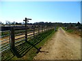
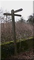
1
Old road sign on Upper Vann Lane
The road to the left is a private drive but the public road continues for another few hundred yards to Vann Hill.
Image: © Dave Spicer
Taken: 24 Jul 2010
0.04 miles
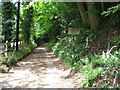
2
Houses near the upper end of Upper Vann Lane
Image: © Dave Spicer
Taken: 24 Jul 2010
0.08 miles
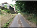
6
Log pile by caravan at Maple Bungalow
It gets cold in a caravan in Winter.
Image: © Dave Spicer
Taken: 24 Jul 2010
0.23 miles
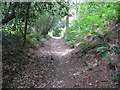
8
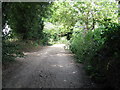
Bridleways crossroads on Vann Hill
The Greensand Way turns left, straight on is to Hydon's Ball and to the right leads to Little Burgate Farm.
Image: © Dave Spicer
Taken: 24 Jul 2010
0.24 miles