IMAGES TAKEN NEAR TO
Godalming Road, GODALMING, GU8 4BQ
Introduction
This page details the photographs taken nearby to Godalming Road, GU8 4BQ by members of the Geograph project.
The Geograph project started in 2005 with the aim of publishing, organising and preserving representative images for every square kilometre of Great Britain, Ireland and the Isle of Man.

There are currently over 7.5m images from over14,400 individuals and you can help contribute to the project by visiting https://www.geograph.org.uk
Image Map (Loading...)


Getting Data...Please wait
Leaflet Map data © OpenStreetMap
Images are licensed for reuse under creativecommons.org/licenses/by-sa/2.0
Notes
- Clicking on the map will re-center to the selected point.
- The higher the marker number, the further away the image location is from the centre of the postcode.
Image Listing (25 Images Found)
Images are licensed for reuse under creativecommons.org/licenses/by-sa/2.0
Image
Details
Distance
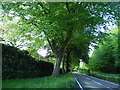
1
Gated entrance to Long Vere Barns
Off the B2130, Godalming Road.
Image: © Robin Webster
Taken: 7 Jun 2011
0.03 miles
2
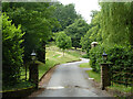
Entrance to Hascombe Grange
Off the B2130, Godalming Road.
Image: © Robin Webster
Taken: 7 Jun 2011
0.11 miles
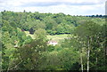
4
36 miles to Brighton
It was a surprise to find Brighton as the ultimate destination on a road that nowadays is of fairly local importance only.
Image: © Robin Webster
Taken: 7 Jun 2011
0.12 miles
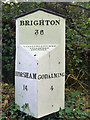
5
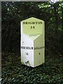
Old Milepost by the B2130, Godalming Road, Hascombe Parish
Cast iron post by the B2130, in parish of HASCOMBE (WAVERLEY District), Godalming Road, by Deer Park Cottage, high on wood side bank, on East side of road. Guildford iron casting, erected by the Godalming & Painshill turnpike trust in the 19th century.
Inscription reads:- : HORSHAM / 14 : : BRIGHTON / 36 : : GODALMING / 4 : : WILLIAMS & FILMER / GUILDFORD / FOUNDRY. :
Milestone Society National ID: SY_HOGO14.
Image: © HK Coleman
Taken: 20 Mar 2005
0.13 miles
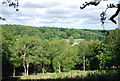
6
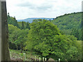
View south-west from Hascombe Hill
The distant hill must be Blackdown.
Image: © Robin Webster
Taken: 7 Jun 2011
0.13 miles
7
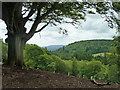
View south-west from Hascombe Hill
The distant hill must be Blackdown.
Image: © Robin Webster
Taken: 7 Jun 2011
0.17 miles
8
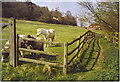
South of Hascombe.
This pasture is on the lower slopes of The Hurtwood. Hurtwood is fairly common in Surrey - hurt is an old dialect name for whortleberry.
Image: © Colin Smith
Taken: 23 Apr 2006
0.18 miles