IMAGES TAKEN NEAR TO
Long Gore, GODALMING, GU7 3TQ
Introduction
This page details the photographs taken nearby to Long Gore, GU7 3TQ by members of the Geograph project.
The Geograph project started in 2005 with the aim of publishing, organising and preserving representative images for every square kilometre of Great Britain, Ireland and the Isle of Man.

There are currently over 7.5m images from over14,400 individuals and you can help contribute to the project by visiting https://www.geograph.org.uk
Image Map
Images are licensed for reuse under creativecommons.org/licenses/by-sa/2.0
Notes
- Clicking on the map will re-center to the selected point.
- The higher the marker number, the further away the image location is from the centre of the postcode.
Image Listing (11 Images Found)
Images are licensed for reuse under creativecommons.org/licenses/by-sa/2.0
Image
Details
Distance
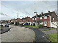
2
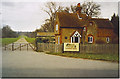
Green Lane at Binscombe
The road on the right is Copse Side.
Image: © Shazz
Taken: 7 Mar 2011
0.14 miles
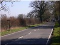
4
South Lodge, Loseley Park.
This is at the south end of the big driveway leading to Loseley House, home of the More-Molineaux.
Image: © Colin Smith
Taken: Unknown
0.15 miles
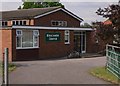
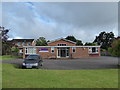
6
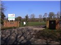
Football Club at Meade's Park
This is on Green Lane at Binscombe.
Image: © Shazz
Taken: 7 Mar 2011
0.19 miles
8
2016: a year on Geograph (Day 182)
Church on the outskirts of Godalming
Image: © Basher Eyre
Taken: 30 Jun 2016
0.24 miles
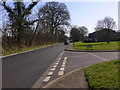
9
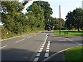
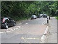
Green lane, Binscombe
Looking east along Green Lane from the junction with Copse Side.
Image: © Alan Hunt
Taken: 8 Sep 2014
0.24 miles