IMAGES TAKEN NEAR TO
Northbourne, GODALMING, GU7 3SQ
Introduction
This page details the photographs taken nearby to Northbourne, GU7 3SQ by members of the Geograph project.
The Geograph project started in 2005 with the aim of publishing, organising and preserving representative images for every square kilometre of Great Britain, Ireland and the Isle of Man.

There are currently over 7.5m images from over14,400 individuals and you can help contribute to the project by visiting https://www.geograph.org.uk
Image Map
Images are licensed for reuse under creativecommons.org/licenses/by-sa/2.0
Notes
- Clicking on the map will re-center to the selected point.
- The higher the marker number, the further away the image location is from the centre of the postcode.
Image Listing (5 Images Found)
Images are licensed for reuse under creativecommons.org/licenses/by-sa/2.0
Image
Details
Distance
1

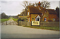
Birch Road, Farncombe.
Bungalow suburbia, ideal retirement ground in Surrey.
Image: © Colin Smith
Taken: Unknown
0.18 miles
3
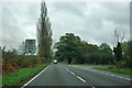
South Lodge, Loseley Park.
This is at the south end of the big driveway leading to Loseley House, home of the More-Molineaux.
Image: © Colin Smith
Taken: Unknown
0.23 miles
4
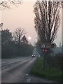
Restricted access to Stakescorner Road
A potential through route towards Guildford is denied.
Image: © Robin Webster
Taken: 9 Nov 2011
0.24 miles