IMAGES TAKEN NEAR TO
Northbourne, GODALMING, GU7 3SG
Introduction
This page details the photographs taken nearby to Northbourne, GU7 3SG by members of the Geograph project.
The Geograph project started in 2005 with the aim of publishing, organising and preserving representative images for every square kilometre of Great Britain, Ireland and the Isle of Man.

There are currently over 7.5m images from over14,400 individuals and you can help contribute to the project by visiting https://www.geograph.org.uk
Image Map (Loading...)


Getting Data...Please wait
Leaflet Map data © OpenStreetMap
Images are licensed for reuse under creativecommons.org/licenses/by-sa/2.0
Notes
- Clicking on the map will re-center to the selected point.
- The higher the marker number, the further away the image location is from the centre of the postcode.
Image Listing (4 Images Found)
Images are licensed for reuse under creativecommons.org/licenses/by-sa/2.0
Image
Details
Distance
1

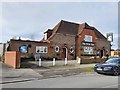
Birch Road, Farncombe.
Bungalow suburbia, ideal retirement ground in Surrey.
Image: © Colin Smith
Taken: Unknown
0.17 miles
3
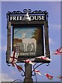
The White Hart Pub Sign in Farncombe
The White Hart Pub Sign in Farncombe on Bourne Road.
Image: © John P Reeves
Taken: 25 Feb 2020
0.24 miles
4
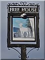
The White Hart Pub in Farncombe
A view of the White Hart Pub in Farncombe from Bourne Road.
Image: © John P Reeves
Taken: 25 Feb 2020
0.25 miles