IMAGES TAKEN NEAR TO
Meadrow, GODALMING, GU7 3JD
Introduction
This page details the photographs taken nearby to Meadrow, GU7 3JD by members of the Geograph project.
The Geograph project started in 2005 with the aim of publishing, organising and preserving representative images for every square kilometre of Great Britain, Ireland and the Isle of Man.

There are currently over 7.5m images from over14,400 individuals and you can help contribute to the project by visiting https://www.geograph.org.uk
Image Map (Loading...)


Getting Data...Please wait
Leaflet Map data © OpenStreetMap
Images are licensed for reuse under creativecommons.org/licenses/by-sa/2.0
Notes
- Clicking on the map will re-center to the selected point.
- The higher the marker number, the further away the image location is from the centre of the postcode.
Image Listing (136 Images Found)
Images are licensed for reuse under creativecommons.org/licenses/by-sa/2.0
Image
Details
Distance
1
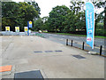
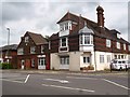
Esso petrol station on Meadrow, Farncombe
Image: © David Howard
Taken: 15 Sep 2013
0.01 miles
2
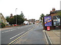
Meadrow, Farncombe
The A3100 between Guildford and Milford
Image: © David Howard
Taken: 15 Sep 2013
0.01 miles
3

Save 1p (per litre)
Seen in Meadrow. Driving past I just saw "Save 1p" Now times are hard so I turned round and went back and found it was "Save 1p per litre" Result!
Image: © Basher Eyre
Taken: 21 Nov 2021
0.01 miles
6
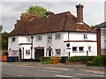
Capital House
The former Half Moon pub in Meadrow, Farncombe, closed c.1984.
Image: © David960
Taken: 3 Jun 2014
0.04 miles
7
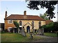
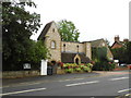
Meadrow Unitarian Chapel
The chapel stands well back from the main road (A3100), partly hidden. Its own notice-board gives a date of 1789. The congregation that founded the chapel was apparently an off-shoot from the Baptist movement - affiliating itself to the Unitarians at some stage in the 19th century: http://www.unitariangodalming.org.uk/history.html According to the present community's website, the chapel's congregation was also responsible for founding the British School, in Bridge Road, Godalming: http://www.geograph.org.uk/photo/3495933
Many of the headstones in the burial ground are quite huge - especially those just to the right of the paved path.
Photo taken in fading light on a July evening.
Image: © Stefan Czapski
Taken: 31 Jul 2014
0.06 miles
8
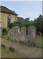
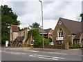
Tombstones at Meadrow Unitarian Chapel
There are a number of tombstones here which by English standards are unusually tall - up to about 1.55m. The inscriptions on most are no longer legible, but they would seem to date from the early days of the chapel- which was founded in 1789. Rather oddly, the path to the chapel's main (north) entrance passes directly over a line of graves.
For a wider view of the chapel see: http://www.geograph.org.uk/photo/4099956
Image: © Stefan Czapski
Taken: 31 Jul 2014
0.06 miles
9
Sweetapple House
On the corner of Catteshall Road and Meadrow, Farncombe. Once the Catteshall Coffee Tavern: https://www.youtube.com/watch?v=kLxA2p-FKjE
Image: © David960
Taken: 3 Jun 2014
0.06 miles
10
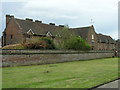
Almshouses located at Wyatts Close
Richard Wyatt Almshouses opened in 1619. See http://www.thecarpenterscompany.co.uk/pages/charities/wyatts_almshouses/default.aspx for information.
Image: © Michael Terry
Taken: 12 Apr 2008
0.07 miles