IMAGES TAKEN NEAR TO
Peperharow Road, GODALMING, GU7 2PS
Introduction
This page details the photographs taken nearby to Peperharow Road, GU7 2PS by members of the Geograph project.
The Geograph project started in 2005 with the aim of publishing, organising and preserving representative images for every square kilometre of Great Britain, Ireland and the Isle of Man.

There are currently over 7.5m images from over14,400 individuals and you can help contribute to the project by visiting https://www.geograph.org.uk
Image Map (Loading...)


Getting Data...Please wait
Leaflet Map data © OpenStreetMap
Images are licensed for reuse under creativecommons.org/licenses/by-sa/2.0
Notes
- Clicking on the map will re-center to the selected point.
- The higher the marker number, the further away the image location is from the centre of the postcode.
Image Listing (16 Images Found)
Images are licensed for reuse under creativecommons.org/licenses/by-sa/2.0
Image
Details
Distance
1
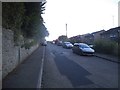
Peperharrow Road, Hurtmore
This is the furthest end of Godalming's suburbs.
Image: © David Howard
Taken: 2 Oct 2016
0.06 miles
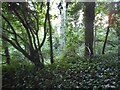
2
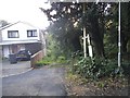
Woods at the end of Peperharrow Road
The end of the road is the only road in this square.
Image: © David Howard
Taken: 2 Oct 2016
0.07 miles
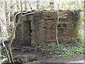
3
Pill Box by Milton Wood
One of many such WW2 fortifications built in the "Stop Line" at the North Downs. It stands at the junction of a drain and the River Wey.
http://www.godalming-tc.gov.uk/
Image: © Colin Smith
Taken: 10 Apr 2012
0.09 miles
4
Pill Box, East End of Milton Wood
WW2 relic on the banks of the Wey upstream from Godalming. This was on the putative "Stop Line" of 1940.
http://www.godalming-tc.gov.uk/
Image: © Colin Smith
Taken: 10 Apr 2012
0.10 miles
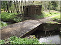
5
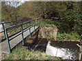
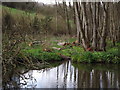
Weir by Milton Wood
Footbridge spanning a small weir at the east end of Milton Wood by Godalming. The weir takes water from the River Wey into a drain.
http://www.godalming-tc.gov.uk/
Image: © Colin Smith
Taken: 10 Apr 2012
0.11 miles
6
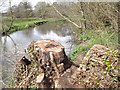
Stumped? Not Here.
Access along this Weyside path between Godalming and Eashing is still possible due to felling and a pathway made right beside this tree stump.
Image: © Colin Smith
Taken: 10 Apr 2012
0.12 miles
8
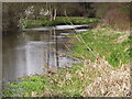
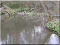
River Wey Below Peperharow Road
Placid stretch of the Wey upstream from Godalming.
http://www.godalming-tc.gov.uk/
Image: © Colin Smith
Taken: 10 Apr 2012
0.14 miles
9
No Way on the Way
A fallen tree across the width of the river prevents any progress here by intrepid canoeists. Upstream from Westbrook Mills, Godalming.
http://www.godalming-tc.gov.uk/
Image: © Colin Smith
Taken: 10 Apr 2012
0.15 miles
10
Logging by the Wey
Small piles of newly cut logs beside a sharp bend in the River Wey above Godalming.
http://www.godalming-tc.gov.uk/
Image: © Colin Smith
Taken: 10 Apr 2012
0.17 miles