IMAGES TAKEN NEAR TO
Old Barn View, GODALMING, GU7 1YR
Introduction
This page details the photographs taken nearby to Old Barn View, GU7 1YR by members of the Geograph project.
The Geograph project started in 2005 with the aim of publishing, organising and preserving representative images for every square kilometre of Great Britain, Ireland and the Isle of Man.

There are currently over 7.5m images from over14,400 individuals and you can help contribute to the project by visiting https://www.geograph.org.uk
Image Map
Images are licensed for reuse under creativecommons.org/licenses/by-sa/2.0
Notes
- Clicking on the map will re-center to the selected point.
- The higher the marker number, the further away the image location is from the centre of the postcode.
Image Listing (4 Images Found)
Images are licensed for reuse under creativecommons.org/licenses/by-sa/2.0
Image
Details
Distance
1
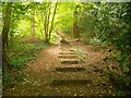
Godalming: Ockford Hill
This is the start of the steepish climb, hence the steps, up the footpath to Pullman Lane from Ockford Road.
Image: © Nigel Cox
Taken: 12 Aug 2015
0.08 miles
4
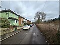
Ockford Ridge - Cliffe Road
Road next to a tributary of the River Wey and the main line Railway.
The London to Cosham line was opened in 1848 by the LSWR.
Wikipedia page : https://en.wikipedia.org/wiki/London_and_South_Western_Railway
Image: © James Emmans
Taken: 12 Mar 2021
0.21 miles