IMAGES TAKEN NEAR TO
Electric Close, GU7 1WQ
Introduction
This page details the photographs taken nearby to Electric Close, GU7 1WQ by members of the Geograph project.
The Geograph project started in 2005 with the aim of publishing, organising and preserving representative images for every square kilometre of Great Britain, Ireland and the Isle of Man.

There are currently over 7.5m images from over14,400 individuals and you can help contribute to the project by visiting https://www.geograph.org.uk
Image Map (Loading...)


Getting Data...Please wait
Leaflet Map data © OpenStreetMap
Images are licensed for reuse under creativecommons.org/licenses/by-sa/2.0
Notes
- Clicking on the map will re-center to the selected point.
- The higher the marker number, the further away the image location is from the centre of the postcode.
Image Listing (68 Images Found)
Images are licensed for reuse under creativecommons.org/licenses/by-sa/2.0
Image
Details
Distance
1

General view from Scizdons Climb
The rising ground on the left is Frith Hill.
Image: © Shazz
Taken: 7 Mar 2011
0.02 miles
2
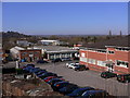
Industrial estate by Godalming
The view is from Scizdons Climb. If you know where to look the masts on the North Downs three miles away can be seen on the skyline.
Image: © Shazz
Taken: 7 Mar 2011
0.02 miles


7

The end of Scizdons Climb
The track beyond the gate is privately owned. A summer view is at http://www.geograph.org.uk/photo/182154.
Image: © Shazz
Taken: 7 Mar 2011
0.06 miles
9

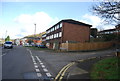
Work on Catteshall Lane, Godalming
It seemed to be to do with drains.
Image: © Robin Webster
Taken: 9 Nov 2011
0.08 miles
10

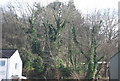
Pond between the Scizdons, Godalming
An unexpectedly pretty pond at the back of an industrial/trading estate off Catteshall Lane in Godalming. The land slopes steeply to the east and west of the pond to form the Scizdons, part of a number of hills in the Godalming area. The tarmacadam surface and traffic cone are the only evidence of the bland trading estate immediately behind the camera.
Image: © Nick McKeon
Taken: 9 Apr 2008
0.10 miles