IMAGES TAKEN NEAR TO
Catteshall Lane, GODALMING, GU7 1UL
Introduction
This page details the photographs taken nearby to Catteshall Lane, GU7 1UL by members of the Geograph project.
The Geograph project started in 2005 with the aim of publishing, organising and preserving representative images for every square kilometre of Great Britain, Ireland and the Isle of Man.

There are currently over 7.5m images from over14,400 individuals and you can help contribute to the project by visiting https://www.geograph.org.uk
Image Map (Loading...)


Getting Data...Please wait
Leaflet Map data © OpenStreetMap
Images are licensed for reuse under creativecommons.org/licenses/by-sa/2.0
Notes
- Clicking on the map will re-center to the selected point.
- The higher the marker number, the further away the image location is from the centre of the postcode.
Image Listing (14 Images Found)
Images are licensed for reuse under creativecommons.org/licenses/by-sa/2.0
Image
Details
Distance
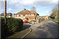
1
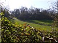
Country Life, Catteshall
Private drive, parkland and a dry valley by Catteshall Manor.
Image: © Colin Smith
Taken: 27 Jun 2009
0.10 miles
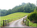
3
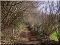
The road to Catteshall Farm seen from the bridleway
Image: © Shazz
Taken: 7 Mar 2011
0.12 miles
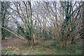
5
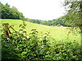
By Catteshall Manor
Parkland scene in a dry valley on the Greensand Ridge above Catteshall, a suburb of Godalming.
Image: © Colin Smith
Taken: 27 Jun 2009
0.16 miles
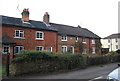
6
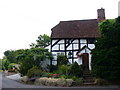
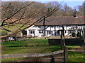
Old Cyder House
The former Ram Cyder House in Catteshall is now residential. The building on Catteshall Lane is still picturesque.
Image]
Image: © Colin Smith
Taken: 27 Jun 2009
0.17 miles
7
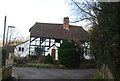
Cyder House Cottage
Formerly the Ram Cyder House, converted to a house.
Image: © N Chadwick
Taken: 27 Jan 2013
0.18 miles