IMAGES TAKEN NEAR TO
Blewfield, GODALMING, GU7 1TR
Introduction
This page details the photographs taken nearby to Blewfield, GU7 1TR by members of the Geograph project.
The Geograph project started in 2005 with the aim of publishing, organising and preserving representative images for every square kilometre of Great Britain, Ireland and the Isle of Man.

There are currently over 7.5m images from over14,400 individuals and you can help contribute to the project by visiting https://www.geograph.org.uk
Image Map
Images are licensed for reuse under creativecommons.org/licenses/by-sa/2.0
Notes
- Clicking on the map will re-center to the selected point.
- The higher the marker number, the further away the image location is from the centre of the postcode.
Image Listing (102 Images Found)
Images are licensed for reuse under creativecommons.org/licenses/by-sa/2.0
Image
Details
Distance
1
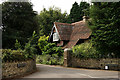
Godalming
Entrance to the Busbridge Hall estate, with the north lodge to the right of picture.
Image: © Peter Trimming
Taken: 27 Aug 2016
0.11 miles
2
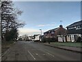
Homefarm Road
The edge of the Godalming suburbs with Busbridge Hall Farm fields on the left.
Image: © James Emmans
Taken: 23 Jan 2021
0.11 miles
5
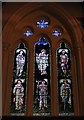
Windows in Busbridge church
This is at the south east end of the building.
Image: © Shazz
Taken: 7 Mar 2011
0.13 miles
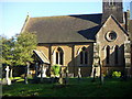
6

High window in Busbridge church
This is at the north west end of the church.
Image: © Shazz
Taken: 7 Mar 2011
0.13 miles
10
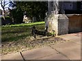
Boot and shoe scraper at porch of Busbridge church
Image: © Shazz
Taken: 7 Mar 2011
0.13 miles